Begur - Pta Mongo

Begur - Pta Mongo

To precisely geolocate this site. Update if necessary.

Localisation

Begur - Pta Mongo
LatitudeLongitude
DMS------
DM------
DD------

Characteristics

Coast

Description

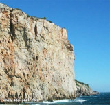
Begur cape has a semaphore in a yellow building at 108 m above sea level..
Between the points "Del Palom" and "La Sal", the cove "Sa tuna" deep 16 to 18 m, homes a fishing village.

The rocky coastline continues for one mile to the W NW of "Las Llosas" (Cape Negro) point.

SE tip Guixeras and 0.5 miles from shore, the group of islands Medas (Medes) consists of three main islands: Grande Meda (Big Island), the small  Meda and the rock(mogote) Bernat and a few rocks which the rock Magallot loose N of Great Meda.

The passage between Great Meda and the continent is healthy, with a width of approximately 0.4 miles.
2012/07/9
Update
Jojo
Begur - Pta Mongo
Begur - Pta Mongo
2014-07-12
Update
Joëlle
Le cap Begur porte un sémaphore dans un édifice de couleur jaune, à 108 m
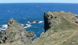
 d'altitude.
Entre les pointes "Del Palom" et de "La Sal", l'anse de "Sa tuna", profonde de 16 à 18 m, abrite un village de pêcheurs.

La côte rocheuse se poursuit pendant un mille à l'W N W de la pointe de "Las Llosas" (cap Nègre).
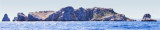
Dans le SE de la pointe Guixeras et à 0,5 milles du rivage, le groupe des îles Medas (des Mèdes) se compose de 3 îles principales: la Grande Meda (Grande île), la petite Meda et le rocher (mogote) Bernat et de quelques rochers dont l'un, le rocher Magallot est bien détaché au N de la Grande Meda.

Le passage entre la Grande Meda et le continent est sain, avec une largeur de 0,4 mille environ.
2014/07/12
Update
Joëlle
Ebook

Espagne Est - East Spain

  • 235 sites
  • 414 photos
  • publication date: 7 Jul 2023
  • .pdf file size: 180 Mb
Share your comments or photos on "Begur - Pta Mongo"

Sites around Begur - Pta Mongo

Flying distances - Direct line

Bahia de Rosas

13nm
348°
Rosas bay lies between Rio Muga and La Bateria (or Blancals) point.
8 Jul 12
Jojo

Illes Medes

1.2nm
60°
The Illes Medes (in Catalan) or Islas Medas (in Spanish) is a small and craggy group of islets i located close to the shore, east of the coastal town of L'Estartit.
Meda Gran, the largest one, has an area of 1.8 km² and is the only island of a considerable size. It has some mediterranean ...
7 Jul 12
Jojo

Puerto l'Estartit

1nm
Estartit is a fishing and Yach club harbour very busy, located in the center of Costa Brava, in front of the sub-maine reserve of Medes islands.Entry is difficult in strong E winds, but it is a good shelter from the Tramontane (NW).Tel: 972 15 44 12Fax: 972 15 37 68Email: info@cnestartit.es738 ...
6 Jul 12
Jojo

Punta Guixeras (Estartit)

1.1nm
20°
Guixeras point is the SE extremity of a promontory located 2 NM NNE of the mouth of the Rio Ter and N Estartit harbour, in front of Medes islands. N and NNW Guixeras point, the coast is rocky and steep, with small coves. It is also bordered by islets.
7 Jul 12
Jojo

Cabo Negre (Begur)

4.1nm
163°
Cabo Negre (or Las Llosas point) is N Cala Sa Tuna. It is overwhelmed by rocks.

The rocky coastline continues for 1 NM to the WNW of this point.
6 Jul 12
Jojo