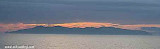
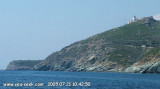
Bastia-Port St Nicolas

Bastia-Port St Nicolas

To precisely geolocate this site. Update if necessary.

Localisation

Bastia-Port St Nicolas
LatitudeLongitude
DMS------
DM------
DD------

Characteristics

VHF canal 12, 16
Harbour

Description

Bastia-Port St Nicolas
2012-05-01
Update
Jojo
Bastia-Port St Nicolas
2005:07:22 14:01:43
2012-05-02
Update
Jojo
Bastia-Port St Nicolas
2005:07:22 14:05:24
2012-05-02
Update
Jojo
Ebook

Corse - Corsica

  • 247 sites
  • 631 photos
  • publication date: 6 Jul 2023
  • .pdf file size: 162 Mb
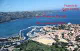
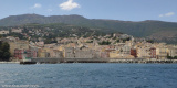
Bastia, the principal commercial port of Corse, comprises three separate harbor areas:

- Port Saint-Nicholas, in the center, is reserved for commercial operations and is the only harbor accessible to commercial vessels

- Vieux-Port, in the S part, is used by fishing vessels and pleasure craft

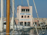
- Port de Plaisance de Toga, in the N part, is used by yachts and small craft.

Winds

The Libeccio, a local W to SW wind, is predominant throughout the year and reaches a maximum frequency in summer. It can be especially violent in this vicinity.

Tides

Tides and currents at Bastia are negligible, the water level being affected mainly by periods of strong winds.


2012/07/6
Update
AB
Située dans le Nord-Est de la Corse, à la base du Cap Corse, Bastia est le principal port de l'île et sa principale ville commerciale.
Avant l'occupation de la Corse par les génois, Cardo était un gros village. À ses pieds, il y avait un petit hameau où habitaient les pêcheurs de Cardo. Ce petit port s'appelait Porto Cardo qui veut dire « le port de Cardo ».
Les génois ont vite senti le besoin de se mettre à l'abri des invasions qui venaient de la mer et ont commencé à construire, du temps du gouverneur Léonello Lomellini, une bastiglia (une bastille), c'est-à-dire une place forte, une citadelle.
Avec le temps, la Bastiglia (Bastia) s'est développée, est devenue prospère et est devenue plus importante que Cardo.
Au cours des 50 dernières années, Cardo était la résidence secondaire de Bastiais aisés.
Actuellement, Cardo est un quartier de Bastia, sur les hauteurs du Pigno. De nombreuses personnes quittent Cardo pour descendre travailler à Bastia. Toute son histoire est comprise dans sa « bastiglia » la citadelle des origines qui constitue la ville close. Ce sont ici la mer et la montagne qui décident de l'implantation des lieux habités, comme l'exige le relief de l'île. Aussi, Bastia fut capitale au temps de la domination génoise. Elle s'est accrochée aux pentes pour s'étaler plus tard, en gagnant sur l'eau sa place Saint Nicolas.

De la modeste marine qu'elle était au port de commerce qu'elle est devenue, son histoire a été jalonnée des gloires et des vicissitudes que connaissait toute ville fortifiée.

Bastia, le principal port commercial de Corse, comprend 3 ports séparés. Le port Saint-Nicholas, au centre est le port de commerce, le Vieux-port, au S, est réservé aux pêcheurs et aux bateaux de plaisance, Port Toga, au N, est réservé à la plaisance.

Le port St Nicolas est le seul port accessible aux bateaux commerciaux.
Quand les quais N et NE sont occupés, les longueurs des cargos ne doivent pas dépasser72 m au quai N et 120 m au quai NE.
Il y a des installations pour le fret général, ro-ro, bulk, ferries,tankers et les navires de croisière. Généralement, les navires jusqu'à 160 m de long et 7 m de TE peuvent être accueillis.

Tel: +33 495559510
Fax: +33 495559655

Vents-Temps:

Le Libeccio, vent W à SW local, est prédominant tout au long de l'année et atteint son maximum en été où il peut être très violent.

2012/05/2
Update
Jojo
Share your comments or photos on "Bastia-Port St Nicolas"

Sites around Bastia-Port St Nicolas

Flying distances - Direct line

Cap Sagro - Bastia

2.8nm
22°
Capo Sagro is located at 11 NM. S Finocchiarola islands. He has a signal station and a semaphore rises N of it.
Mount Merizatodio, 778 m high, is 1.5 MN to W Cape and dominates the immediate area. The village of Erbalunga, situated 1.5 miles SSW of Capo Sagro, stands on the S ...
6 May 12
Jojo

Isola Capraia

25nm
38°
Capraia is one of the seven islands of the Tuscan Archipelago, on the road between Cape Corsica and Elba. It is an island of 335 inhabitants (the Capraiesi) of the Province of Livorno. It lies 64 km from Livorno, 37 km from Gorgona and 31 km from Corsica. Its area is 19 km2. It has ...
26 Feb 14
marchew

Golfe de St Florent

7.3nm
266°
The Gulf of Saint Florent form a large body of water open to the North to NW winds, but sheltered by the mountains Libeccio of Balagne.
Strong wind blows from east sometimes jump off the mountain which is extended by the Cap Corse and a rise in the Gulf chop rather unpleasant.
The ...
6 May 12
Jojo

Cap Sagro

5.7nm
15°
Located between Marines de Sisco and Erbalunga, this point is well known to divers.
Cape Sagro is an anchorage where the ancient Roman fleet landed the goods for this part of Cap Corse.

This site is of outstanding beauty and it is not unusual to see diving teams of experienced ...
1 May 12
Jojo

Bastia - Vieux Port

0.3nm
193°
Its geographical location makes it a safe shelter against the prevailing winds and waves, especially the libeccio, that often blows on the Cap Corse. By east wind there are chop and surf in the outer harbor, that must be considered.

Easy access through an inlet NE, it is recommended ...
2 May 12
Jojo

Bastia - Port Toga

0.5nm
Zeer luide discotheek NAAST Uw boot tot 02:00! Price is €90 for a 42ft sailing boat, not cheap at all. Toilet and douches are moderate.
24 Jul 16