An amazing armada of Allied troops, British, American, Canadian and more, landed on Normandy's beaches on 6th June 1944 to begin the liberation of Europe from years of Nazi occupation. The planners of this crucial event for European freedom codenamed it D-Day.
2019/06/6
Update
azerty
Antifer fait référence à:
zone météo,
Cap d'Antifer
Port pétrolier du Havre - Antifer
Dans cette zone se trouvent las plages du débarquement du 6 Juin 1944.
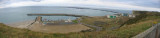
Port du Havre-Antifer (Le Havre-Antifer), a large oil terminal, is situated about 9 miles N of Cap de la Heve, close S of Cap d’Antifer. The port is exposed to winds and swell between S and W. Local regulations are in force to prevent incidents due to bad weather. Strong winds ...
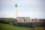
Cap d’Antifer, a prominent cape, is fronted by a steep cliff, 122m high. Cap d’Antifer Light is shown from a conspicuous tower, 38m high, standing on top of the cliffs at the cape. The coast between this cape and Cap de la Heve, about 11 miles SSW, is formed by reddish-colored ...
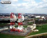
Le premier sémaphore du site est construit vers 1860, près des deux phares de La Hève. Il est évacué en 1905 en raison de l'éboulement de la falaise. La marine nationale reconstruit un sémaphore plus au sud de cap de La Hève. Il est totalement détruit durant les bombardements ...
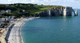
Etretat, situated about 2 miles NE of Cap d’Antifer, is a small town that lies within the valley of Etretat. A conspicuous monument in the form of a spire, sometimes illuminated in summer, stands on the E cliff of the valley. L’Aiguille d’Etretat, 51m high, is a pointed detached ...
L'entrée à toutes heures de la marée, se fait facilement. Il ny a pas de ponton carburant. Les pompes sont situées à la station service. Sport garanti pour faire le plein et du gasoil partout en prévision. Marina insipide près du béton et triste au possible. Je ny suis ...


 An amazing armada of Allied troops, British, American, Canadian and more, landed on Normandy's beaches on 6th June 1944 to begin the liberation of Europe from years of Nazi occupation. The planners of this crucial event for European freedom codenamed it D-Day.
 Antifer fait référence à: