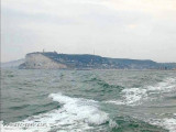
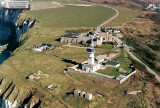
Cap d’Antifer, a prominent cape, is fronted by a steep cliff, 122m high. Cap d’Antifer Light is shown from a conspicuous tower, 38m high, standing on top of the cliffs at the cape. The coast between this cape and Cap de la Heve, about 11 miles SSW, is formed by reddish-colored cliffs, about 100m high, except at the N end. At the N end of this stretch the cliffs are white and can be easily seen from seaward when the sun shines on them. A water tower stands 0.7 mile SSW of Cauville, about 5 miles NNE of Cap de la Heve, and is the most prominent landmark along this stretch of shore.
2012/05/5
Update
Geof
Au cap d'Antifer se trouve un phare en forme de tour octogonale à faces incurvées de 37,90 mètres de hauteur au-dessus du sol et 102 mètres au-dessus du niveau de la mer. Il a été mis en service en 1955. Son feu à 1 éclat 20 s, éclairé par une lampe halogène de 650 W, a une portée de 23,7 milles.
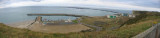
Port du Havre-Antifer (Le Havre-Antifer), a large oil terminal, is situated about 9 miles N of Cap de la Heve, close S of Cap d’Antifer. The port is exposed to winds and swell between S and W. Local regulations are in force to prevent incidents due to bad weather. Strong winds ...
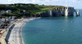
Etretat, situated about 2 miles NE of Cap d’Antifer, is a small town that lies within the valley of Etretat. A conspicuous monument in the form of a spire, sometimes illuminated in summer, stands on the E cliff of the valley. L’Aiguille d’Etretat, 51m high, is a pointed detached ...
L'entrée à toutes heures de la marée, se fait facilement. Il ny a pas de ponton carburant. Les pompes sont situées à la station service. Sport garanti pour faire le plein et du gasoil partout en prévision. Marina insipide près du béton et triste au possible. Je ny suis ...
Le premier sémaphore du site est construit vers 1860, près des deux phares de La Hève. Il est évacué en 1905 en raison de l'éboulement de la falaise. La marine nationale reconstruit un sémaphore plus au sud de cap de La Hève. Il est totalement détruit durant les bombardements ...
Fecamp, lying in a valley close S of Point Fagnet, is a small port with facilities for commercial vessels, fishing boats, and pleasure craft. The harbor consists of Avant-port, Arriere port, Bassin de Mi-Maree, and two non-tidal basins.With winds from the W through N to NE, visibility ...
Histoire En 1902, la mise en service du phare de la jetée Sud entraîne la fermeture de celui de la vierge. Le ministère de la marine décide alors d'y transférer le sémaphore. En effet, bien que jouxtant l'ancien et culminant à 104 mètre, il offre une meilleur base d'observation. En ...


 Cap d’Antifer, a prominent cape, is fronted by a steep cliff, 122m high. Cap d’Antifer Light is shown from a conspicuous tower, 38m high, standing on top of the cliffs at the cape.