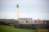
Port du Havre-Antifer (Le Havre-Antifer), a large oil terminal, is situated about 9 miles N of Cap de la Heve, close S of Cap d’Antifer. The port is exposed to winds and swell between S and W. Local regulations are in force to prevent incidents due to bad weather. Strong winds may reduce the water level in the port by up to 0.5m. The tides rise about 8m at MHWS and 6.6m at MHWN. The tidal currents usually run parallel to the shore and attain a maximum rate of 3 knots at springs.
2012/05/5
Update
Geof
Terminal pétrolier composé de deux appontements construits à l'abri d'une digue : poste Est accessible aux navires de plus de 270 m de long et poste Ouest pour les navires de plus de 310 m de long.
2007/11/27
Update
Anonymous
Share your comments or photos on "Port du Havre-Antifer"
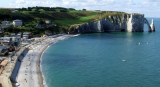
Cap d’Antifer, a prominent cape, is fronted by a steep cliff, 122m high. Cap d’Antifer Light is shown from a conspicuous tower, 38m high, standing on top of the cliffs at the cape. The coast between this cape and Cap de la Heve, about 11 miles SSW, is formed by reddish-colored ...
Etretat, situated about 2 miles NE of Cap d’Antifer, is a small town that lies within the valley of Etretat. A conspicuous monument in the form of a spire, sometimes illuminated in summer, stands on the E cliff of the valley. L’Aiguille d’Etretat, 51m high, is a pointed detached ...
L'entrée à toutes heures de la marée, se fait facilement. Il ny a pas de ponton carburant. Les pompes sont situées à la station service. Sport garanti pour faire le plein et du gasoil partout en prévision. Marina insipide près du béton et triste au possible. Je ny suis ...
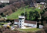
Le premier sémaphore du site est construit vers 1860, près des deux phares de La Hève. Il est évacué en 1905 en raison de l'éboulement de la falaise. La marine nationale reconstruit un sémaphore plus au sud de cap de La Hève. Il est totalement détruit durant les bombardements ...
Histoire Dans le cadre du projet initié en 1854 par le ministère de la marine qui prévoyait la création d'un réseau de postes éléctro-sémaphoriques, la marine fait l'acquisition en 1908 du terrain actuel. La construction du sémaphore débute en 1910 et il entre en service ...


 Le Havre Antifer harbour
 Port du Havre-Antifer (Le Havre-Antifer), a large oil terminal, is situated about 9 miles N of Cap de la Heve, close S of Cap d’Antifer.
 Terminal pétrolier composé de deux appontements construits à l'abri d'une digue : poste Est accessible aux navires de plus de 270 m de long et poste Ouest pour les navires de plus de 310 m de long.