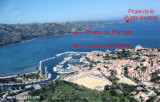
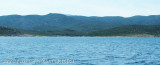
NM at NE of "l'Ile Rousse", this cove, named also Porajola or Parajola, is bordered by a beautiful beach S from a tower genoese and a white cliff.
The shelter is good by SE winds, but exposed to those of West. A river flows south from the beach and creates extended half-swamp behind the sand barrier.
Here we are at the southern and quiet limit of the desert Agriates. The road N1197 provides flow of swimers on the beach at Ostriconi bottom of loop.
2012/05/8
Update
Jojo
2006:07:18 11:32:03
2012-05-08
Update
Jojo
A 9 miles au Nord-Est de l'île Rousse, cette anse, appelée aussi Porajola ou Parajola, est bordée par une belle plage au Sud d'une tour génoise et d'une falaise blanchâtre.
L'abri est bon par vents de Sud à l'Est, mais exposé à ceux d'Ouest. Une rivière se jette au Sud de la plage et crée des étendues à demi-marécageuses en arrière du cordon de sable.
Ici on se trouve à la limite sud et tranquille du désert des Agriates. La route N1197 apporte son flot de baigneurs sur la plage de l'Ostriconi en fond d'anse.
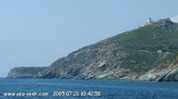
Capo Sagro is located at 11 NM. S Finocchiarola islands. He has a signal station and a semaphore rises N of it. Mount Merizatodio, 778 m high, is 1.5 MN to W Cape and dominates the immediate area.
The village of Erbalunga, situated 1.5 miles SSW of Capo Sagro, stands on the S ...
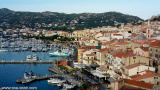
The Gulf of Saint Florent form a large body of water open to the North to NW winds, but sheltered by the mountains Libeccio of Balagne. Strong wind blows from east sometimes jump off the mountain which is extended by the Cap Corse and a rise in the Gulf chop rather unpleasant.
The ...
The shore at the foot of Mount Orlando 107m high, has an appearance very rocky and steep cut.
However, when it is perfectly calm sea, moor between two heads of rocks on the eastern flank of Acciolu (174 m) where the falling stone submarines are very beautiful. Note however ...
This first beach after Ile Rousse, just east of a Genoese tower, offers no shelter from sea winds. However, it is very crowded in good weather as the road passes nearby and a large holiday village was built just to the east.
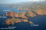
The nature reserve, which is part of the Regional Natural Park of Corsica, occupies the Scandola peninsula, an impressive, porphyritic rock mass. The vegetation is an outstanding example of scrubland. Seagulls, cormorants and sea eagles can be found there. The clear waters, with their ...
The entrance is clear of any danger and we dropped anchor in the center of the loop by 2 to 3m of water. This indentation offers a shelter suitable for moderate wind from west, which is very rare throughout the Agriates desert. But the anchorage in the entrance is exposed to the ...


 NM at NE of "l'Ile Rousse", this cove, named also Porajola or Parajola, is bordered by a beautiful beach S from a tower genoese and a white cliff.
 A 9 miles au Nord-Est de l'île Rousse, cette anse, appelée aussi Porajola ou Parajola, est bordée par une belle plage au Sud d'une tour génoise et d'une falaise blanchâtre.