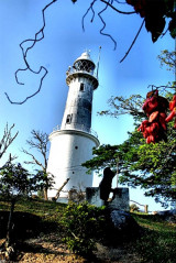

Selangor lighthouse (Selangor Malaysia)
10nm
19°
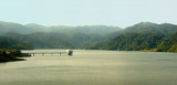
Caution.—The banks off the mouth of the Sungai Selangor are reported to be extending seaward.
24 Dec 11
Jojo
| Latitude | Longitude | |
| DMS | --- | --- |
| DM | --- | --- |
| DD | --- | --- |


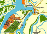
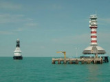
 Angsa Bank North Cardinal Light Float is moored off the NW end of Angsa Bank, about 15miles W of Kuala Selangor Light.
The bottom is soft and not likely to damage a vessel touching, and the water is invariably smooth. From a position about 12 miles W of Kuala Selangor light, a vessel should steer SE into the strait.
Upon sighting Pulau Angsa, the vessel should steer for it, bearing 154° until about 4 miles from it.
Bukit Jugra, a hill, just open E of Pulau Angsa, bearing 150°, will lead between the W mud bank and Batu Penyu. A light is shown from
Bukit Jugra, Pulau Angsa, and Batu Penyu.
When abreast of Pulau Angsa, the course should be altered to about 130° to pass through the dredged channel of which ahs a depth of 11.1m.
The lighthouse at Pulau Angsa is linked by VHF with the Harbormaster’s office at Port Kelang.
Fishing stakes extend into deep water on either side of the strait but are generally within the 10m curve. They are continually being shifted, but do not extend into the main channel.
Fishing boats at times frequent the approach to Selat Kelang Utara (North Kelang Strait) in great numbers and lay their drift nets across the channel. These nets are marked by wooden floats and have a boat at each end of the net.
Caution.—Uncharted drying banks lie from 2.75 miles SW to 4.5 miles W of the E entrance point to Kuala Selangor.
Ebook | Strait of Malacca (East)
|
Ebook | Sumatra (Indonesia)
|