Amazon Mara Shoal, with a least depth of 8.4m, lies about 2.2 miles S of One Fathom Bank Light.
A dangerous wreck, marked by a lighted buoy, lies in the southeastbound lane of the Traffic Separation Scheme. Another dangerous wreck, with a depth of 16m over it, lies 10 miles WNW of One Fathom Bank and is situated near the N edge of the southeastbound traffic lane.
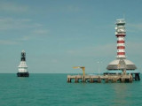
One Fathom Bank (2°53'N., 100°59'E.) is a detached patch, with depths from 3 to 10m, which extends 5 miles in a NW direction reaching 1 mile in width. One Fathom Bank Light is situated 0.6 mile from the SE extremity of the bank. A stranded wreck is situated about 0.7 mile NW ...
Pyramid Shoal, which lies on the N side of the SE end of South Sands, has a least depth of 3.4m, hard sand, and is the most dangerous shoal in the area because of its depth and protrusion into the fairway. A lighted buoy is moored about 7 miles SE of Pyramid Shoal. A depth of about ...
Selat Lumut separates the E side of Pulau Lumut from the mainland. It has a least width of about 0.1 mile, with both sides of the S entrance fringed by mud banks. Selat Lumut has not been surveyed in detail, but appears to be navigable by vessels of not more than 3m draft. From ...
Tg Ru is located E side of the approach to Selat Kelang, on Pulau Carey, It is the S point of the South fairway of port Klang . The coast between Tanjong Ru and Tanjong Gabang, about 15 miles SE, is indented about midway along its length by Kuala Langat. This shallow river is not ...
Kampong Morib, which is conspicuous, stands 3.75 miles SSE of the entrance of Kuala Langat. Kuala Langat is famous for its agricultural produce, industries that
recycle scrap metal, home stay programmes for tourists and for its
National Space Centre in Kanchong Darat. Fishermen's ...
Angsa Bank North Cardinal Light Float is moored off the NW end of Angsa Bank, about 15miles W of Kuala Selangor Light. The bottom is soft and not likely to damage a vessel touching, and the water is invariably smooth. From a position about 12 miles W of Kuala Selangor light, a ...


 Amazon Mara Shoal, with a least depth of 8.4m, lies about 2.2 miles S of One Fathom Bank Light.
