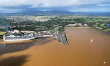
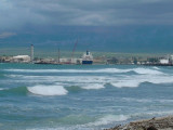
On the south
shore of Hanamaulu bay, semi-protected by a breakwater, is an old warf which was once
used for offloading sugar. Now it serves as a place to fish and drink
beer.
2015/12/4
Update
Joëlle
Share your comments or photos on "Ahukini Landing"
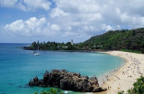
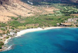
Just 3 miles north of Nawiliwili is Hanamaulu Bay, an excellent anchorage
in westerlies. With no nearby mountains, the winds blow steadily at about
the same speed as out at sea. The bay shoals gradually and predictably
to a nice beach park with showers and picnic tables.In westerly ...
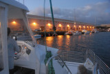
Nawiliwili Harbor is home to a small boat harbor and a cruise ship and cargo commercial port.
Located at the mouth of Hule'ia Stream and near Niumalu Beach park, it may look familiar as the backdrop for the movie Raiders of the Lost Ark.
Kalapaki
Wahiawa Bay is a bay in Hawaii, situated between Weli Point and Glass Beach. Wahiawa Bay is close to Port Allen Small Boat Harbor and Eleele Shopping Center. Excellent anchorage
in strong trades. The NE trade wind blows down the bay but the fetch is
so short that no chop can develop ...
Located in Port Allen on Kauai's south shore, the Port Allen Marina
Center serves the local growing visitor and boating industry. The 23,600
square-foot marina center was completed in August 2002 and is home to a
diverse range of local retailers, boating tour companies and gift ...
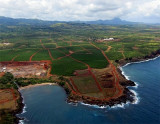
Waimea bay is located in Haleiwa, on the N shore of Oahu, at the mouth of the Waimea river. Waimea valley extends behind Waiema bay.Waiema means "red water" in Hawaiian.Captain Charles Clerke aboard HMS Resolution stopped at Waimea Bay on February 28, 1779. Clerke had shortly before ...
This is a huge anchorage directly in front of a wide valley. The valley was use for bombing
practice during WWII. You can still see the observation towers used by the military. Now,
however, a fight has erupted between the government and the Hawaiians over the protection of
the ...


 On the south
shore of Hanamaulu bay, semi-protected by a breakwater, is an old warf which was once
used for offloading sugar. Now it serves as a place to fish and drink
beer.
On the south
shore of Hanamaulu bay, semi-protected by a breakwater, is an old warf which was once
used for offloading sugar. Now it serves as a place to fish and drink
beer.