Off the coast of Nias lie 2
other islands - Pulau Bawa and Pulau Aru. Pulau Bawa is excellent for
surfing. The W coast of Pulau Nias is nearly inaccessible
because of surf Tanjung Sosilutte, about 2 miles SE of Tanjung Tojolawa,
is a low point with a remarkable tree, and it is the S extremity of the
Tojolawa Peninsula, on the slopes of which are the buildings of a
coconut plantation.
Pulau Pulau Hinako forms a group of eight islands, of which Pulau Hinako is the most populated. They are all of coral formation, covered with coconut trees, and flat, with the exception of Pulau Hinako, which has a small ridge on its NW side, on which is a mission church and school. ...
Pulau Wunga, about 8 NM S of Pulau Mausi, is low andcovered with coconut trees. A large conspicuous tree, visible for 16 miles, is located on a small elevationnear the N end. The reef extending from the N side of the island is ordinarily marked by high rollers; on the S side ...
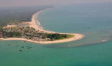
Tanjung Sirombu, lying about 34 miles SSE of Tanjung Sosilutte, is low and wooded and may be identified by several tall casuarina trees which stand above the other trees. The point is marked by a light. From a distance it resembles an island, but from closer in the low wooded sandy ...
Pulau Mausi, low and barren, lies in the S approach to Labuan Atjeh, about 2.2 miles SE of Tanjung Sosilutte. It has a white sandy beach, and is fringed by a reef onwhich the sea always breaks, extending about 1 mile S; there is a depth of 7.7m at the outer end of the reef. An ...
Pulau Sarangbaung lies 10.5 miles NNE of the N extremity of Pulau Nias. There is a break in the reef on the SE side where boats can land at a village. The island is overgrown with coconuts and is visible for 12 miles.
Gunung Sitoli (Gunungsitoli is the capital and the port of Nias. It is located about 14 NM NW of Tg Lambaru and forms a deep bight. At its head the hills approach the shore, leaving a strip of lowland between them. 6.29 The mouth of the river, leading to the port, will just ...


 Off the coast of Nias lie 2
other islands - Pulau Bawa and Pulau Aru. Pulau Bawa is excellent for
surfing. The W coast of Pulau Nias is nearly inaccessible
because of surf Tanjung Sosilutte, about 2 miles SE of Tanjung Tojolawa,
is a low point with a remarkable tree, and it is the S extremity of the
Tojolawa Peninsula, on the slopes of which are the buildings of a
coconut plantation.
Off the coast of Nias lie 2
other islands - Pulau Bawa and Pulau Aru. Pulau Bawa is excellent for
surfing. The W coast of Pulau Nias is nearly inaccessible
because of surf Tanjung Sosilutte, about 2 miles SE of Tanjung Tojolawa,
is a low point with a remarkable tree, and it is the S extremity of the
Tojolawa Peninsula, on the slopes of which are the buildings of a
coconut plantation.