Pulau pulau Hinako (W Nias)

Pulau pulau Hinako (W Nias)

Per individuare con precisione. Aggiornare se necessario.

Localizzazione

Caratteristica

Isola / Atoll
Faro
Surf

Descrizione

Pulau Pulau Hinako forms a group of eight islands, of which Pulau Hinako is the most populated.
They are all of coral formation, covered with coconut trees, and flat, with the exception of Pulau Hinako, which has a small ridge on its NW side, on which is a mission church and school. A light is shown fromPulau Hinako.

Between and in the vicinity of the islands are numerous reefs, for which the chart should be consulted. The 20m curve must be considered the limit of safety at Pulau Hinako, as nearly everywhere within this curve are drying reefs or reefs with little depth.

The W side of the four outer islands, with exception of the coast reefs on which there are usually breakers, is clear. By passing the islands at a distance of 1 mile, one will always carry considerable depths.

Hinako Islands: Asu and Bawa are two breaks in this island chain. 

Pulau Bawa is atoll-shaped. The seaward side of all of the islands consists of a raw coral mass which is practically impassable except at Pulau Bawa, of which the W side has been washed smooth.

Caution.—Vessels approaching Pulau Pulau Hinako from the N must be careful to avoid the 5.9m patch about 4.7 miles NNE of the light structure of Pulau Hinako.

2012/02/6
Aggiornare
Jojo
Ebook

Sumatra (Indonesia)

  • 326 sites
  • 109 photos
  • publication date: 7 Aug 2024
  • .pdf file size: 109 Mb
Condividi i tuoi commenti o le foto su "Pulau pulau Hinako (W Nias)"

Siti intorno a Pulau pulau Hinako (W Nias)

Flying distances - Direct line

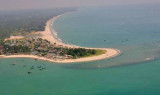
Pulau Wunga (W Nias)

25nm
325°
Pulau Wunga, about 8 NM S of Pulau Mausi, is low andcovered with coconut trees.
A large conspicuous tree, visible for 16 miles, is located on a small elevationnear the N end.
The reef extending from the N side of the island is ordinarily marked by high rollers; on the S side ...
6 Feb 12
Jojo

Tanjung Sirombu (W Nias)

6.6nm
43°
Tanjung Sirombu, lying about 34 miles SSE of Tanjung Sosilutte, is low and wooded and may be identified by several tall casuarina trees which stand above the other trees. The point is marked by a light. From a distance it resembles an island, but from closer in the low wooded sandy ...
6 Feb 12
Jojo

Pulau Mausi (W Nias)

32nm
334°
Pulau Mausi, low and barren, lies in the S approach to Labuan Atjeh, about 2.2 miles SE of Tanjung Sosilutte.
It has a white sandy beach, and is fringed by a reef onwhich the sea always breaks, extending about 1 mile S; there is a depth of 7.7m at the outer end of the reef.
 An ...
6 Feb 12
Jojo

Pulau Senau (N Nias)

36nm
351°
From Pulau Senau, lying about 11 miles ENE of Tanjung Tojolawa, the coast is completely exposed to N and NW squalls.
They are prevalent here during the months of October, November, and the first part of December; they may be exceptionally heavy and cause a heavy swell and much ...
4 Feb 12
Jojo

Ujung Sumabawa (E Nias)

34nm
95°
Between tg Tedulehu and Ujung Sumabawa, about 11 miles N, the coast is high, with mountain ranges approaching the coast.
Ujung Sumabawa is marked by a light.
A low plain begins here and extends N, gradually getting wider.
About 1 mile W of Ujung Sumabawa, landing may be effected ...
6 Feb 12
Jojo

Karang Makassar (E Nias)

41nm
96°
Makassar Reefs are four isolated dangers, with depths of 3 to 8.2m, and deep channels between them.
They lie from 1.75 to 7 miles S of Sumabawa, and from 6 to 7 miles offshore. They are marked by breakers or a heavy swell.
6 Feb 12
Jojo