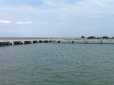
Pak Nam Satun (or Satul) lies about 10 miles NE of Pulau Langkawi and is well sheltered by the islands from the Southwest Monsoon.Satun is one of the southern provinces of Thaïland.The name Satun is a Thai version of its original Malay name: Setul.Until 1813 Satun was a district ...
Paknam Satul (Pak Nam Satun) lies about 10 miles NE of Pulau Langkawi and is well sheltered by the islands from the Southwest Monsoon. The port town of Kuala Perlis (Sungai Perils) lies about 7 miles SSE of Paknam Satul; coasting vessels anchor off it, in 5.5m, SW of a group of ...
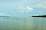
Located E coast of Malaysia.It's the most easterly anchorage for Langkawi. Being surrounded by a cluster of islands adds to the calm conditions in most winds, but being close to the open sea, sometimes there's a
bit of ground swell to contend with. The water is clean ...
From the Sungai Kedah the coast, with an adjoining mud flat, extends in a S direction for a distance of about 26 miles to the entrance of the Sungai Merbok (Merbau River), and continues low and wooded until within 8 or 9 miles of that river, where the conspicuous Gunong Jerai, 1,212m ...