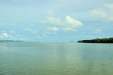
Pulau Timun (Langkawi)
14nm
247°
bit of ground swell to contend with. The water is clean ...
27 Nov 11
Jojo
| Latitude | Longitude | |
| DMS | --- | --- |
| DM | --- | --- |
| DD | --- | --- |

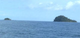
The port town of Kuala Perlis (Sungai Perils) lies about 7 miles SSE of Paknam Satul; coasting vessels anchor off it, in 5.5m, SW of a group of four islands.
A mud flat fronts the coast.
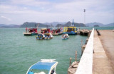
Kuala Perlis, located at the mouth of the Sungai Perlis (Perlis River), is the second largest town and the main port of Perlis in Malaysia. It is in extreme northwest Peninsular Malaysia, near the border with Thailand. The older part of town has houses and mosques built on stilts over mangrove swamps.
Kuala Perlis is also famous for its seafood, especially Laksa.
The small port in town is mainly used for fishing and loading or unloading small-scale cargo arriving from Thailand and Indonesia. There are also customs and immigration offices here, where those going further on into Thailand via Satun province can stamp out before embarking on the 45-minute boat journey to enter Thailand at Thammalang near Satun.
Tel: 6 04 - 9852690
Fax : 6 04 -9852691
")
")
Ebook | Andaman sea
|