Tanjung Lambaru, located about 8 miles NW of Ujung Onolimbu, is swampy and thickly overgrown; dead trees stand on it and in the water close off it.
At Tanjung Lambaru it has a width of 8 miles. The coast consists of a sandy beach, off which rocks are lying. The sea usually breaks, making landings very difficult.
Pulau Wunga, about 8 NM S of Pulau Mausi, is low andcovered with coconut trees. A large conspicuous tree, visible for 16 miles, is located on a small elevationnear the N end. The reef extending from the N side of the island is ordinarily marked by high rollers; on the S side ...
Ujung Onolimb lies about 6 miles NW of Tanjung Sjuani. Onolimbu Road has good anchorage, in depths of 21.9m to 25.6m, mud. It is close to shore, abreast a road leading to Tagaule village. There is another anchorage off Bodsyihona village to the N, in a depth of 18.3m. Local knowledge ...
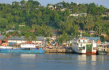
Gunung Sitoli (Gunungsitoli is the capital and the port of Nias. It is located about 14 NM NW of Tg Lambaru and forms a deep bight. At its head the hills approach the shore, leaving a strip of lowland between them. 6.29 The mouth of the river, leading to the port, will just ...
North of Gunungsitoli, the coast is covered with coconut trees for about 6 miles.Close N of Gunungsitoli is Tanjung Mbaa, a rocky point from which a light is shown. From Tanjung Mbaa, a narrow strip of coast land extends about 3 miles NW, then a fringing reef leads up to Tanjung ...


 Tanjung Lambaru, located about 8 miles NW of Ujung Onolimbu, is swampy and thickly overgrown; dead trees stand on it and in the water close off it.