
Water islands (Malacca - Malaysia)
34nm
242°
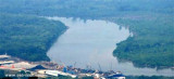
The Water Islands, centered about 8 miles SE of Melaka, consists of a group of six tree-covered islands of moderate ...
5 Jan 12
Jojo
| Latitude | Longitude | |
| DMS | --- | --- |
| DM | --- | --- |
| DD | --- | --- |


 channel 16


 The Sungai Muar, a shallow river available only to small craft, discharges into the strait about 14 miles ESE of Pulau Besar.
The river is tortuous but small craft with drafts of 1.8m can ascend to Kepong Hill about 60 NM above the entrance. A radio mast stands on the E bank of the river close within the entrance.
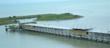
Muar is also a town and port, also known as Bandar Maharani for most of the local people staying there.
Muar, the headquarters of the state commissioner, is the second port in importance in Johore Province and has a considerable trade. Ocean-going vessels work cargo at the anchorage. Small vessels and barges can be accommodated at the river wharves abreast the town.
Depths alongside these wharves are about 2m. The entrance bar has a least depth of 1.2m.
Anchorage can be taken by small vessels, in a depth of 4m, off the mouth of the Sungai Muar. Larger vessels can anchor about 4 miles WSW of the lighthouse at the entrance, in a depth of 7m, thick mud, good holding ground.
Bukit Mor (1°59'N., 102°41'E.), an isolated densely-wooded hill, 235m high, stands about 8 miles SE of the town of Muar.
")
Ebook | Strait of Malacca (East)
|
Ebook | Sumatra (Indonesia)
|