Lanai island (Hawaii)

Lanai island (Hawaii)

Per individuare con precisione. Aggiornare se necessario.

Localizzazione

Lanai island (Hawaii)
LatitudeLongitude
DMS------
DM------
DD------

Caratteristica

Isola / Atoll

Descrizione

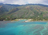
Lanai island, also known as "Pineapple island" because of its past as an island-wide pineapple plantation.

The island's only settlement of note is the small town of Lānaʻi City.

As of 2012, the island was 98% owned by Larry Ellison (Founder and Chairman of Oracle), with the remaining 2% owned by the state of Hawaii.

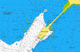
It is separated from the island of Molokaʻi by the Kalohi Channel to the north, and from Maui by the ʻAuʻau Channel to the east.

There is one school, Lanai High and Elementary School, serving the entire island from kindergarten through 12th grade. There are no traffic lights on the island.

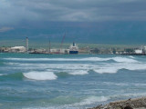
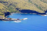
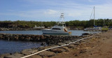
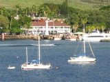
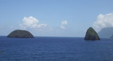
Lanai has a few small indentations that might offer a limited bit of protection as anchorages in calm conditions.

2015/12/11
Aggiornare
Joëlle
Ebook

Hawaii

  • 47 sites
  • 63 photos
  • publication date: 7 Jul 2023
  • .pdf file size: 14 Mb
Condividi i tuoi commenti o le foto su "Lanai island (Hawaii)"

Siti intorno a Lanai island (Hawaii)

Flying distances - Direct line

Kaumalapau Harbor (Lanai Hawaii)

4.4nm
219°
Located on the southwestern coast, Kaumalapau is the main commercial seaport for Lanai.
The original harbor breakwater located here was built in 1920’s but was severely damaged by hurricanes. A new breakwater was built by the U.S. Army Corps of Engineers and was dedicated on ...
10 Dec 15
Joëlle

Manele small boat harbor (Lanai Hawaii)

6.7nm
154°
Manele Harbor, located on Lanai’s south shore, has the only public boat harbor on the island. Visitors who take the ferry from Lahaina on neighboring Maui arrive here (five times daily), as well as a few fishing and snorkeling tour boats. Manele Harbor’s activity is limited ...
11 Dec 15
Joëlle

Lahaina bay (Maui Hawaii)

14nm
79°
There is a marina here but you can forget it. It is always super packed and all but impossible to get a “slip”. Just go past the marina and harbor entrance and find an open mooring buoy with LYC painted on it. In 2010, these buoys were white and there were 7 of them. Most of them ...
11 Dec 15
Joëlle

Kaunakakai harbor (Molokai Hawaii)

15nm
340°
Kaunakakai is a small town with a small harbor fisheriy management area, on the south shore of the island of Moloka'i.
It provides a good protected anchorage from all but the worst kona storms.The harbor was dynamited out of the solid coral.’ Anchor past the commercial barge ...
10 Dec 15
Joëlle

N Okala island (Molokai Hawaii)

20nm
North Molokai island, between Kahiu point and Kukaiwaa point, there are two small islands (Mokapu and Okala), really just giant rocks, eastern-most Mokapu and next to the black sand beach Okala.Leave the islands on the port side and anchor in 25 feet, black sand bottom. You ...
10 Dec 15
Joëlle

Pukoo harbor (Molokai Hawaii)

15nm
30°
On the south east coast of Molokai, this little harbour is worth the effort of negotiating the entrance through the reef.Most of the inner harbour is a private facility, but the three areas in the outer harbour all offer safe anchorages. There is a dinghy landing near the palm trees ...
10 Dec 15
Joëlle