Clare Island is an island guarding the entrance to Clew Bay. The permanent population is around 120 people and the island has a shop with a post office, two bars, a restaurant, a few BnBs, a primary school and a daily ferry service to Roonagh quay. The island is the highest of all the Irish offshore island and offers excellent hill and cliff walking.
The cliff at the Northern tip of Clare island viewed from the top of the island, with Achil beg and the Southern entrance of Achill sound in the background.
unknown
unknown
2017-01-04
Aggiornare
Anonymous
View from Clare Island
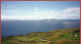
View from the top of Clare island looking south towards Caher and Inishturk, with the Connemara mountains in the background
unknown
unknown
2017-01-04
Aggiornare
Anonymous
Condividi i tuoi commenti o le foto su "Clare Island"
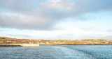
Le port de Clare Island est bien protege des vents d'ouest, mais completement ouvert aux vents d'est. La nouvelle jetee exterieure est utilisee par les ferries, et les bateaux de plaisance ne peuvent donc s'y ammarer que de facon tres temporaire. Il est possible d'echouer ...
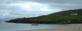
Le phare marque l'entree sud de l'etroit passage entre l'ile d'Achill et Curraun. Le petit port de peche de
Cloghmore (a l'extreme sud d'Achill) offre un abri sur par tous les temps, mais la barre a l'est d'Achill beg brise par grosse houle au jusant, et l'entree dans ces conditions ...
Marks the entrance to Rosmoney pier (where the Mayo Sailing club now has a floating pontoon) and the main entrance to Westport harbour. Good anchorage E of Inishlyre, where it is also possible to come alongside. It is also possible to anchor in the small bay East of Collanmore ...
La lanterne du phare, situee, a 60 m au dessus du niveau de la mer, fut
brisee par une vague dans une tempete en mars1861. Cet incident donne un
idee de la violence de la mer dans ces parages.