Clare Island harbour

Clare Island harbour

Per individuare con precisione. Aggiornare se necessario.

Localizzazione

Clare Island harbour
LatitudeLongitude
DMS------
DM------
DD------

Caratteristica

Porto

Descrizione

Clare Island harbour
View of Clare island harbour at low tide, looking South with the new pier on the left
Christophe Mouze
03/01/2017
2017-01-03
Aggiornare
Anonymous
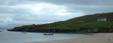
Le port de Clare Island est bien protege des vents d'ouest, mais completement ouvert aux vents d'est.
La nouvelle jetee exterieure est utilisee par les ferries, et les bateaux de plaisance ne peuvent donc s'y ammarer que de facon tres temporaire. Il est possible  d'echouer le long de la jetee interieure, sur un fond de sable. En mortes eaux, il y a environ deux metres d'eau au bout de la jetee interieure (au milieu de la photo), et il serait donc possible d'y rester a flot.
Il y a des douches, des toilettes et une laverie sur le cote ouest du foyer municipal (le grand batiment au dessus de la plage, qui est aussi un pub) et le grand batiment bleu au nord du port est un hotel / restaurant.  La boutique et la poste sont au village, sur la cote sud a 15 mn de marche.
Il y a l'eau sur les deux jetees, mais pas de gasoil.
L'ete, les coffres jaunes sont des mouillages visiteurs gratuits. Sinon, on peut mouiller sur ancre, fond de sable de bonne tenue dans l'avant port, a l'ecart des nombreux coffres, ou echouer dans l'arriere port ou au sud de la plage.
2017/01/4
Aggiornare
The harbour on Clare Island offers good shelter from all wind with West in them, but is completely open to Easterlies.
Do not come alongside the new (outer) pier, which is used by ferries. It is possible to dry out alongside the inner pier, or indeed anywhere in the inner harbour, which has a clean, sandy bottom. There is about .5m at LWS at the end of the inner pier, while the old stone quay completely dries out (see picture).
Shower and toilets are available at the community centre (the large building just over the beach, North of the harbour), and there's a pub and restaurant within easy walking distance. The shop and post office is a mile away. 
In the summer, there are (free!) visitor moorings (yellow bouys).
2017/01/3
Aggiornare
christophe
Ebook

Shannon

  • 34 sites
  • 7 photos
  • publication date: 8 Jul 2023
  • .pdf file size: 16 Mb
Clare Island harbour
Clare island harbour
Clare island harbour viewed from the ferry en route to Roonagh Quay, with the new pier in the foreground on the left.
Armen
January 2017
2017-01-04
Aggiornare
Anonymous
Condividi i tuoi commenti o le foto su "Clare Island harbour"

Siti intorno a Clare Island harbour

Flying distances - Direct line

Clare Island

2.3nm
281°
Clare Island is an  island guarding the entrance to Clew Bay. The permanent population is around 120 people and the island has a shop with a post office, two bars, a restaurant, a few BnBs, a primary school and a daily ferry service to Roonagh quay.
The island is the highest ...
2 Jan 17
Joëlle

Achillbeg

3.4nm
Le phare marque l'entree sud de l'etroit passage entre l'ile d'Achill et Curraun. Le petit port de peche de Cloghmore (a l'extreme sud d'Achill) offre un abri sur par tous les temps, mais la barre a l'est d'Achill beg brise par grosse houle au jusant, et l'entree dans ces conditions ...
2 Jan 17

Inishgort

10nm
81°
Marks the entrance to Rosmoney pier (where the Mayo Sailing club now has a floating pontoon) and the main entrance to  Westport harbour. Good anchorage E of Inishlyre, where it is also possible to come alongside. It is also possible to anchor in the small bay East of Collanmore ...
2 Jan 17

Blacksod

18nm
347°
White tower on dwelling. Character:Fl (2) WR 7.5s
19 Aug 07

Broadhaven

28nm
Language / Langue / Lingua / Idioma 
1 Jan 17

Eagle Island

29nm
350°
La lanterne du phare, situee, a 60 m au dessus du niveau de la mer, fut brisee par une vague dans une tempete en mars1861. Cet incident donne un idee de la violence de la mer dans ces parages.
1 Jan 17