Admiral
Marina & Leisure Club is within Admiral Cove.
Admiral Cove is a concept realised from a desire to create a world class premier
integrated marina resort. Located along the unsploit plains of Port Dickson,
it is today a major international tourist destination.
Tel: (06) 647 0888 Fax: (06) 647 0880
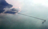
mega yacht berthing
pontoon of 120 metres in length 126 b. (<18 m)
Office staff here will do your clearance paperwork.
Pyramid Shoal, which lies on the N side of the SE end of South Sands, has a least depth of 3.4m, hard sand, and is the most dangerous shoal in the area because of its depth and protrusion into the fairway. A lighted buoy is moored about 7 miles SE of Pyramid Shoal. A depth of about ...
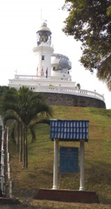
Tanjung Tuan, also called Cape Rachado,
is the site of the oldest - and still functioning - lighthouse in
Malaysia. Cape Rachado Lighthouse, also called Rumah Api Tanjung Tuan,
was built somewhere between 1528 and 1529 by the Portuguese to help
guide ships to the Malacca port. ...
Port Dickson is situated on the W coast of the Malaysian Peninsula facing the Strait of Malacca. The town stretches along the coast in the direction of Tanjung Tuan, located 8 miles SE. Port Dickson is an important oil terminal operated by Shell and Esso, and is a minor port for ...
Pulau Borong, a low densely-wooded rock-fringed islet surrounded by a shallow bank, stands 1.5 miles N of Tanjong Kamuning (that is steep-to with depth of 11 m).
Sungai Linggi is indented by a shallow bay. Good anchorage can be taken off the river entrance, in a depth of 16.5m, mud, with Tanjong Tuan Light bearing 292° and the beacon in the entrance of the river bearing 075°.
Bambeck Shoal, the nearest shoal on the NE side lies on the NE side of the fairway.
Bambek shoal, about 4 NM offshore, lies SW of the mouth of Sungai Sepang Besar. It has a depth of 0,3 m near its center and is composed of hard sand. Its NW and SE sides are steep-to with ...


 channel 14


 in town
 Admiral
Marina & Leisure Club is within Admiral Cove.
Admiral
Marina & Leisure Club is within Admiral Cove.")
")