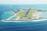
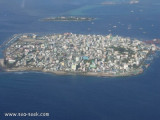
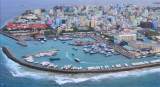
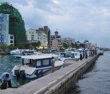
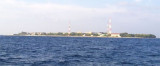
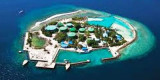
Male, the principal port, is centrally situated at NW corner of Male. Male' Commercial Harbour is situated on the NW side of Male' island.
All cargo vessels are handled at Alongside and as well as at anchorage using Barge operation. Most of the container ships are handled at Alongside Berth.
The port handles all types of cargo except dry bulk, liquefied petroleum and gases.
The harbour area also incorporates a marina.
Approaches:Except in very heavy rain the S.W monsoon, the visibility is good. And landfall can be made easily. The TV tower, south of Male’ in position : Lat 04 10.2N Long. 73 30.9 E. is visible at a distance of 30 miles. The dome of the Islamic centre in position : Lat 04 10.7 N. Long 73 30.85 E. and the minaret of Grand Mosque (Islamic Centre) in position : Lat 04 10.69 N. Long 73 30.83 E. are also visible for approaching vessels.
Vessels approaching Male port should contact Harbour control on VHF channel 10 two hours prior to arrival pilot boarding ground (Lat 04 10.0 N Log. 073.32.0 E)
Passages:
Gaadhoo Koa,(Male Passage) the passage between the reefs fringing Male and Hulhule, is about 4 cables wide at its outer end and has a depth of 35m in the fairway. At its inner end the passage divides, passing each side of Funadhoo with deep water in both channels. The North Channel is recommended. The Gaadhoo Koa is the recommended approach to the anchorage North of Male for all vessels at safe speed. Bodukalhi, (Kanduoiygiri Passage) is 8 cables wide at its outer end and has a depth of 40m in the fairway. Male Viligili passage is another safe passage safe entrance to Male anchorage. Mariners should exercise caution when using this channel as a shoal of 5.0m lies in the centre of the channel.
Gaadhoo Koa Channel Lights: Navigational Lights have been installed to mark Gaadhoo Koa Channel. Please refer BA chart 3323
Mooring: 3 Head line to shore Bollard 70t and 2 Astern Line to shore Bollard 70 t
Cruise Vessels: Passenger vessels are handled at anchorage. Number of berths available: None
Specialised Cargo Facilities: No Ro-Ro berths. Containers and conventional cargo are handled at Berth and at Anchorage.
Tanker Facilities: Tanker terminal is available at Funadhoo and Thilafushi Island. Vessels below 15000 tons displacement and draft of 8.0m can be handled at these berths. Tankers are also handled at anchorage, and ship-to-ship transfer is possible. Two mooring buoys are fitted near Hulhule Island (Male International Airport).
LPG/LNG Facilities: Gas Tankers (LPG) terminal is available at Thilafushi Island two terminal one STO PLC Terminal and one Vila gas terminal. Vessels length 130m draft 8meters can be berthed in these two terminals.
Hoses: International connection can be used.
Cargo Operations: Vessels are handled on first come first serve basis.
Stevedores: The Maldives Ports Limited is the sole stevedoring company. Average load/discharge rate is 2,500 f/t per day, depending on type of commodities, ship’s gear and port situation. Overtime is possible, Saturday to Wednesday for 2 hours after midnight, if the vessel is expected to complete its loading or unloading within 2 hours and on Thursday from 2400-0800 hrs. if the vessel can complete within the additional 8 hours.
Fresh Water: Fresh water is available on request in any quantity. Average supply rate 15 m/t per hour.
Fuel: MGO/available at berths by bunker barges and small Tanker ships at anchorage.
Chandlery: Ship supply service can be arranged through ship’s Agent.
Services: Radar/Gyro and communications equipment repairs possible from Maldives Electronic Service Company (MESCO) Tel: +960 -332 3536. Fax: +960 3316741
Repairs: Workshops are available for mechanical repairs. Limited fabrication/steel work is available.
Opening / Closing Hatches: Normally done by ships crew. However port stevedores can open and close hatches on request.
Shore Leave: Possible after inward clearance is granted.
Repatriation: Facilities exist for effecting crew changes and arranging necessary repatriation.
Identification Cards: Seaman’s book/Passport. Or ship ID card can be use while leaving and entering gates.
Ship Stores : Loading of ship store Customs permission required.
2011/11/19
Mettre à jour
Jojo


 canal 10


")