Vijayadurg Harbor (W India)

Vijayadurg Harbor (W India)

Pour géolocaliser ce lieu. Mettre à jour si besoin.

Localisation

Vijayadurg Harbor (W India)
LatitudeLongitude
DMS------
DM------
DD------

Caractéristiques

Mouillage
Sable
Plage
Sable

Description

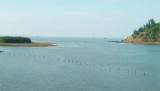
Vijayadurg Harbor is entered between Burmana Point, 24m high, and a point about 1.5 miles NNE.
Burmana Reef, over which the sea breaks, extends about 0.2 mileWNW and 0.2 mile NNW of Burmana Point. An 8.2m shoal lies about 0.2 mile NW of the same point.

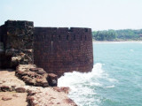
A conspicuous fort stands on a projecting rocky point, about 26m high and 0.8 mile ENE of Burmana Point. This point forms the W side of the entrance to the Vaghotan River. The fort is obscured from the S by the higher land in that direction.

Depths in the harbor decrease regularly from about 12m in the entrance to the E shore of the bay.
Depths in the fairway between the point on which the fort lies and a cliff, 19m high, about 0.7 mile ENE, are about 6.5m, but decrease sharply farther within the river to 3.7m.

Anchorage can be taken anywhere in the harbor, according to draft, during good weather.

2012/03/2
Mettre à jour
Jojo
Vijayadurg Harbor (W India)
2012-03-02
Mettre à jour
Jojo
Ebook

Arabian Sea

  • 132 sites
  • 73 photos
  • publication date: 6 Jul 2023
  • .pdf file size: 49 Mb
Partagez vos remarques ou photos sur "Vijayadurg Harbor (W India)"

Sites autour de Vijayadurg Harbor (W India)

Flying distances - Direct line

Vijayadurg Point (W India)

1nm
206°
Vijayadurg Light is shown from a white steel tower with red horizontal bands on the NE corner of the fort. Vijayadurg, a small village, is situated about 0.8 mile S of the light.Anchorage can be taken in about 0.5 mile NNE of Vijayardurg Light, in 8m, mud.The coast between Vijayadurg ...
2 Mar 12
Jojo

Wagapur Point (W India)

1.6nm
329°
A light is shown from a tall, white, square, concrete tower with black bands on Wagapur Point; foul ground extends about 0.1 mile WNW of the point.
The coast between Wagapur Point and Vijayadurg Harbor, about 2 miles S, consists of cliffs about 21m high. Holi Hill, 85m high, about ...
2 Mar 12
Jojo

Purangad Point (W India)

13nm
353°
Purangad lighthouse is shown, except during the strength of the Southwest Monsoon, from the N entrance point of Purangad Bay. About 1 mile farther E, a ruined fort stands on a bare hill on the N side of the entrance to the Machkandi River.
Khavri, a mountain 346m high, lies about ...
2 Mar 12
Jojo

Pavas Bay (W India)

19nm
351°
Pavas Bay (Paos Bay) is entered S of Pavas Point, Golap Hill, 120m high, lies about 1 mile NE of Pavas Point.
Vessels can anchor in Pavas Bay, in a depth of about 8.5m, mud and sand, sheltered from NW winds.
The coast between Pavas Bay and Purangad Bay, about 5 miles S, consists ...
2 Mar 12
Jojo

Achra Point (W India)

23nm
167°
Achra Point, 41m high, is the N entrance point of the Achra River, which is only accessible to boats.
A light is shown during good weather from the point.The coast from the mouth of the Achra River to the entrance of Kalavali Creek, about 7 miles SSE, is sandy and fringed with ...
3 Mar 12
Jojo