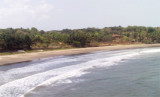
A light is shown from a tall, white, square, concrete tower with black bands on Wagapur Point; foul ground extends about 0.1 mile WNW of the point. The coast between Wagapur Point and Vijayadurg Harbor, about 2 miles S, consists of cliffs about 21m high. Holi Hill, 85m high, about ...
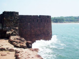
Vijayadurg Harbor is entered between Burmana Point, 24m high, and a point about 1.5 miles NNE. Burmana Reef, over which the sea breaks, extends about 0.2 mileWNW and 0.2 mile NNW of Burmana Point. An 8.2m shoal lies about 0.2 mile NW of the same point. A conspicuous fort stands ...
Vijayadurg Light is shown from a white steel tower with red horizontal bands on the NE corner of the fort. Vijayadurg, a small village, is situated about 0.8 mile S of the light.Anchorage can be taken in about 0.5 mile NNE of Vijayardurg Light, in 8m, mud.The coast between Vijayadurg ...
Purangad lighthouse is shown, except during the strength of the Southwest Monsoon, from the N entrance point of Purangad Bay. About 1 mile farther E, a ruined fort stands on a bare hill on the N side of the entrance to the Machkandi River. Khavri, a mountain 346m high, lies about ...
Pavas Bay (Paos Bay) is entered S of Pavas Point, Golap Hill, 120m high, lies about 1 mile NE of Pavas Point. Vessels can anchor in Pavas Bay, in a depth of about 8.5m, mud and sand, sheltered from NW winds. The coast between Pavas Bay and Purangad Bay, about 5 miles S, consists ...
Mudle Shoal (Taylor Shoal), with a least depth of 1.1m, and marked on its S side by a buoy, lies about 0.7 mile SE of Miyet Point. The sea breaks over this shoal at LW.


 Musakazi Point is about 21m high.