Achra Point (W India)

Achra Point (W India)

Pour géolocaliser ce lieu. Mettre à jour si besoin.

Localisation

Achra Point (W India)
LatitudeLongitude
DMS------
DM------
DD------

Caractéristiques

Phare

Description

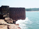
Achra Point, 41m high, is the N entrance point of the Achra River, which is only accessible to boats.

A light is shown during good weather from the point.

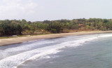
The coast from the mouth of the Achra River to the entrance of Kalavali Creek, about 7 miles SSE, is sandy and fringed with coconut palms. A range of hills of moderate height, with no conspicuous peaks, about 4 miles inland, extends roughly parallel with the coast.

Kura Patches, with a least depth of 9.6m, lies about 2 miles SSW of Achra Point.

2012/03/3
Mettre à jour
Jojo
Ebook

Arabian Sea

  • 132 sites
  • 73 photos
  • publication date: 6 Jul 2023
  • .pdf file size: 49 Mb
Partagez vos remarques ou photos sur "Achra Point (W India)"

Sites autour de Achra Point (W India)

Flying distances - Direct line

Kura Islet (W India)

6nm
172°
Kura Islet, 9m high and the largest of three rocks, lies in the center of a group of rocks, about 1.3 miles NW of the entrance of Kalavali Creek. A 10.5m patch lies about 2 miles NNW of Kura Islet and about 1.5 miles offshore.A 5m patch lies about 0.7 mile S of Kura Islet.
3 Mar 12
Jojo

Vijayadurg Point (W India)

22nm
345°
Vijayadurg Light is shown from a white steel tower with red horizontal bands on the NE corner of the fort. Vijayadurg, a small village, is situated about 0.8 mile S of the light.Anchorage can be taken in about 0.5 mile NNE of Vijayardurg Light, in 8m, mud.The coast between Vijayadurg ...
2 Mar 12
Jojo

Vijayadurg Harbor (W India)

23nm
347°
Vijayadurg Harbor is entered between Burmana Point, 24m high, and a point about 1.5 miles NNE.
Burmana Reef, over which the sea breaks, extends about 0.2 mileWNW and 0.2 mile NNW of Burmana Point. An 8.2m shoal lies about 0.2 mile NW of the same point.
A conspicuous fort stands ...
2 Mar 12
Jojo

Wagapur Point (W India)

24nm
345°
A light is shown from a tall, white, square, concrete tower with black bands on Wagapur Point; foul ground extends about 0.1 mile WNW of the point.
The coast between Wagapur Point and Vijayadurg Harbor, about 2 miles S, consists of cliffs about 21m high. Holi Hill, 85m high, about ...
2 Mar 12
Jojo

Machlimar Point (W India)

26nm
152°
Machlimar Point, 85m high, lies about 3.5 miles SSE of Vengurla Point. The entrance of the Talavda River lies about 1 mile SSE of the point.
3 Mar 12
Jojo