Teluk Kualacenaku (Amphitrite Bay) (E Sumatra)

Teluk Kualacenaku (Amphitrite Bay) (E Sumatra)

Pour géolocaliser ce lieu. Mettre à jour si besoin.

Localisation

Teluk Kualacenaku (Amphitrite Bay) (E Sumatra)
LatitudeLongitude
DMS------
DM------
DD------

Caractéristiques

Description

Teluk Kualacenaku is about 20 miles wide between Tanjung Bakau and Tanjung Dato, a low headland, and about 17 miles long to the mouth of the several rivers of which it is the estuary. The coast is everywhere low and marshy, and the greater portion of the bay is very shallow.
The coast affords no conspicuous landmarks, being completely overgrown by trees, which are all of one kind.
Vessels approaching the bay from the E, when Tanjung Dato or Tanjung Bakau are not visible, may be set considerably N or S by the tidal currents; these tidal currents may attain a rate of
2.5 knots.

The outer edges of the mud banks extending from the entrance points of the bay are steep-to, having depths of 18.3 to 20.1m within 0.5 mile of the 5m curve in places; these mud banks should be given a wide berth. Fishing enclosures may be seen on the shallow banks in various parts of the bay.

Outside Teluk Kualacenaku, the flood current sets to the S and ebb to the N.
In the bay, to about 4 miles from the shore, the flood sets to the W, S of Tanjung Dato, and continues from S to SW between Pulau Busung (Boesoeng) and Pulau Jawang (Tjawang) into Batang Toeaka, but S of Pulau Busung this current sets SW into Batang Terboeng.

The flood also sets SW, or on to the NE edge of the 5m curve, 9 miles S of Tanjung Dato. The ebb from abreast Pulau Busung sets to the N and then continues to the E along the coast to the S of Tanjung Dato. In the middle of the bay, the ebb sets to the E. The greatest rate of the tidal current observed was 3 knots.

2012/02/29
Mettre à jour
Jojo
Ebook

Sumatra (Indonesia)

  • 326 sites
  • 109 photos
  • publication date: 7 Aug 2024
  • .pdf file size: 109 Mb
Partagez vos remarques ou photos sur "Teluk Kualacenaku (Amphitrite Bay) (E Sumatra)"

Sites autour de Teluk Kualacenaku (Amphitrite Bay) (E Sumatra)

Flying distances - Direct line

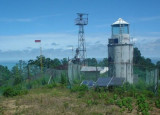
Pulau Burung (Burung-E Sumatra)

34nm
349°
Pulau Burung (Boeroeng), 4 miles NNW of the entrance of the Sungai Kateman, is low, wooded, and separated from the Sumatera coast by a narrow channel.  Pulau Burung is a drying bank extends from 1 to 2 miles from the ends of the island.
Kateman Island and Pulau Burung are ...
27 Feb 12
Jojo

Pulau Cempah - Pulau Laut (Indonesia)

42nm
67°
Pulau Cempah (Tjempah) is irregularly shaped, hilly and about 5 miles long and 2 miles wide. It is separated from the NW part of Pulau Bakung and Blandok Besar and Karoti by Selat Cempah (Tjempah Strait, 2 miles wide, which has general depths of about 24m.
Pulau Cempah is fairly ...
27 Feb 12
Jojo

Tanjung Dato (E Sumatra)

11nm
50°
Located at the south-western tip of Sarawak on the Datu (or Dato) Peninsula, Tanjung Dato is one of Sarawak’s less accessible natural parks, but its relative remoteness is one of its main attractions. The beaches really are undisturbed, the corals offshore are untouched ...
27 Feb 12
Jojo

Merodong group (Indonesia)

56nm
57°
The Merodong group of islands lie to the W of Pulau Mesanak, between it and the Temiang group. The former group comprises six islands, separated by channels unsuitable for navigation and there is no reason in venturing among them or between them and Pulau Mesanak.
Merodong, the ...
10 Feb 12
Jojo

Pulau Sikeling - Blanding - Lobam (Indonesia)

37nm
63°
Pulau Sikeling, 91m high and about 1 mile long, lies 1 mile S of Pulau Buaya.
Blanding lies about 1 mile NW of Pulau Sikeling; it is the S of three islands located on a reef that extends about 4 miles NW.
Lobam, 84m high, lies on the N part of this reef. Turka lies between Blanding ...
27 Feb 12
Jojo

Pulau Alangtiga - Beralas - Muci (W pulau Singkep)

32nm
136°
Pulau Alangtiga, 79m high, lying about 30 miles NW of Pulau Berhala, is the central of a group of three small thickly-wooded islands fringed by reef, and some rocks above-water.
Pulas Beralas, 69m high, lies about 1 mile N of Pulau Alangtiga.
Pulau Muci (Mubi), 81m high, lies ...
26 Feb 12
Jojo