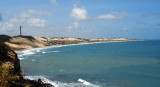
The coral atoll is built on the upper, western part of the flat top of a volcanic seamount on the north east part of the Brazilian continental margin. The seamount rises to a depth of 30 to 15 metres (98 to 49 ft) below the surface. The distance from the reef to the edge of the top of the seamount is about 1 kilometre (0.62 mi) to the west, 5 kilometres (3.1 mi) to the north west and 12 kilometres (7.5 mi) to the east.[3] The sediment in the lagoon and surrounding the atoll is mostly coarse sand, much of which originates from the corals and mollusc shells.
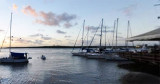
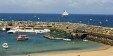
It is a natural anchorage place, just off the breakwater, which provides protection for the dinghy when landing.
However, this anchorage is reported to be rolly. In the winter months
(July) the seas here are generally calm. A stone pier was built for tieing up small ships. Bigger ...
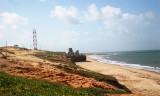
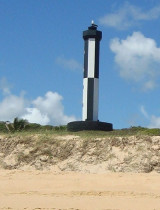
Cap sablonneux d'environ 55m de haut, avec de la végétation à son sommet. C'est le plus proche du continent africain. Il marque en outre la séparation entre la Guyane française (où la côte est basse et marécageuse) et l'Etat du Rio Grande do Norte qui offre, vers le S, une ...
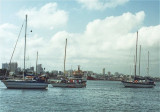
C'est un port de commerce situé à l'embouchure du fleuve Pontengi. Cette rivière se jette dans la mer grâce à une ouverture dans la barrière de corail qui forme un brise-lame naturel pour le port.Les vents dominants, la plupart de l'année, sont en provenance du ENE à SE.Pour ...


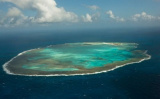


 The coral atoll is built on the upper, western part of the flat top of a volcanic seamount on the north east part of the Brazilian continental margin. The seamount rises to a depth of 30 to 15 metres (98 to 49 ft) below the surface. The distance from the reef to the edge of the top of the seamount is about 1 kilometre (0.62 mi) to the west, 5 kilometres (3.1 mi) to the north west and 12 kilometres (7.5 mi) to the east.[3]