
Iate Clube do Natal (Rio Grande do Norte Brazil)
0.2nm
5°
Tel: +55 84 3202-4402
90 pl. (<18 m)
6 Apr 15
Joëlle
| Latitude | Longitude | |
| DMS | --- | --- |
| DM | --- | --- |
| DD | --- | --- |


")
Ebook | NE Brazil
|
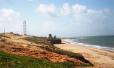
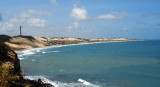
 C'est un port de commerce situé à l'embouchure du fleuve Pontengi. Cette rivière se jette dans la mer grâce à une ouverture dans la barrière de corail qui forme un brise-lame naturel pour le port.
Les vents dominants, la plupart de l'année, sont en provenance du ENE à SE.
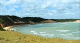
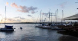
Pour la plaisance, il faut aller mouiller devant le club nautique un peu avant, au nord.
Tel: 84 4005 5311
Mail: administrativo@codern.com.br
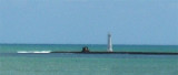
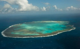
 The port of Natal is situated at the mouth of the Rio Pontengi. The river flows into the sea through an opening in the barrier reef. The barrier reef forms a natural breakwater for the port.
The prevailing winds most of the year are from the ENE to SE.
Formalities can be carried out at the yacht club.
If this is your final port of call in Brazil, you will need to go to the Policia Federal in Natal, half an hour away by car, and the Receita Federal Office and Capitania Dos Portos in the nearby port.
There is also a good anchorge at Rio Potengi.
Provisioning is easy at several supermarkets in the city.