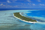

Great Nicobar island
66nm
156°
The island covers 1045 km² but is sparsely inhabited.
The island was severely affected by the 2004 Indian Ocean earthquake tsunami with many deaths, and was cut off ...
30 Nov 11
Jojo
| Latitude | Longitude | |
| DMS | --- | --- |
| DM | --- | --- |
| DD | --- | --- |

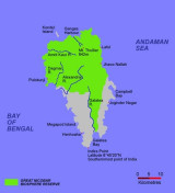
The northern group includes:
Car Nicobar (127 km²)The central group includes
Chowra (8 km²)Isle of Man and Tillangchong (17 km²) - which are both uninhabited, with Tillangchong being a designated wildlife sanctuary.
The southern group includes
Great Nicobar (1045 km²)
Little Nicobar (157 km²)
Kondul (4 km²)
Pulomilo (1 km²)
Meroe, Trak, Treis, Menchal, Kabra, Pigeon and Megapod - all of which are uninhabited islets, with Megapod being a designated wildlife sanctuary.
On 26 December 2004, several islands were heavily damaged with initial reports of islands broken in two or three pieces and coral reefs moved above water.
In the Nicobar Islands, heavy rains occur from May through November. More moderate amounts occur from December through mid-January, and relatively small amounts from January through April.
As a rule, the islands with the higher elevation receive the greatest amount of rain.
Thunderstorm frequency varies from island to island. The greatest activity occurs during those months immediately preceding and the first few weeks immediately following the onset of the Southwest Monsoon. Thunderstorms occur most frequently during May and June at Port Blair, when about 4 to 6 days per month have them. In November, thunderstorms occur on the average of 3 days per month at this port.
The cloud cover is more uniform, with cloud amounts increasing from N to S. During the Southwest Monsoon, there is little diurnal variation in cloud cover. During the remainder of the year the cloud cover is more extensive in the afternoons.
The cloudiest months are June through September. During these months the cloud coverage amounts to 70 to 80 per cent, with few clear days. February and March are the months with least cloud coverage. During these months there is 30 to 40 per cent coverage in the N and 50 to 60 per cent coverage in the S.
The visibility is good except during heavy rains.
The currents in the vicinity of Car Nicobar Island flow rapidly enough to cause tide races, particularly N of the island. During the month of February, usually a calm month, from a position about 6 to 8 miles E of the island, a current setting SW at a rate of 7 knots has been experienced about 1.5 hours after HW.
The tidal currents in the vicinity of Chowra Island set NE during the rising tide and SW during the falling tide.
The tidal currents in the vicinity of Chowra Island set NE during the rising tide and SW during the falling tide.
The tidal currents in St. Georges Channel are strong and set NE through the channel on the rising tide, and SW through the channel on the falling tide.
Ebook | Andaman sea
|