Manche - English Channel

Manche - English Channel

Pour géolocaliser ce lieu. Mettre à jour si besoin.

Localisation

Manche - English Channel
LatitudeLongitude
DMS------
DM------
DD------

Caractéristiques

Côte

Description

Manche - English Channel
2011-04-20
Mettre à jour
La Manche  est une branche de l'océan Atlantique qui sépare la Grande-Bretagne du nord de la France. De grandes îles sont situées dans la Manche comme l'île de Wight au large de la côte anglaise  les Îles anglo-normandes au large des côtes de la France.  Le littoral, en particulier sur la rive française, est profondément échancrée comme la péninsule du Cotentin en France qui s'avance dans la Manche . Au nord de l'île de Wight se trouve le canal de Solent. 


Courants et Marées

En entrant dans  la Manche par l'ouest le chenal se rétrécit, les courants rotatifs deviennent progressivement de plus en plus rectiligne. Les taux des courants dans le chenal varient en fonction de la largeur, et sont les plus importants dans les parties les plus étroites.
Dans le milieu de la Manche, entre Portland et la Pointe Ste-Catherine, sur la côte anglaise, et le Cap de la Hague et la pointe de Barfleur, sur la côte française, les courants peuvent atteindre 3,5 noeuds. Dans les parties les plus larges, les courants atteignent rarement des taux supérieurs à 2,5 noeuds.
Bien que le courant de surface a une dominante NE et E ensemble directionnelle, il est fortement influencé par le vent, qui est variable dans le sens durant toutes les saisons, bien que les vents W prédominent.

Les heures de marée changents rapidement le long de la côte française, et est d'environ 6 heures plus tard au Havre qu'à l'île d'Ouessant. Le moment où la marée s'inverse diffère considérablement localement. Les flux, par conséquent, ne peut pas être décrit comme «montant» et «reflux», et sont généralement appelés E et W. Cependant, il faut comprendre que le courant E est celle qui va jusqu'à la Manche, de l'Atlantique vers Douvres , et le courant W ce qui coule  de Douvres  vers l'Atlantique.

Les directions réelles des courants différent considérablement de l'Est ou l'Ouest. Dans les estuaires et les rivières, les courants sont généralement appelé le «entrant» et «sortants», mais peut être appelé contre les montants et le reflux. Parmi les îles Anglo-Normandes, les heures et les directions de l'écoulement diffèrent grandement de ceux dans le chenal de la Manche. Par conséquent, une grande attention est requise lorsque vous approchez les localités ci-dessus. Les courants de marée dans des endroits à l'W et NW de l'île d'Ouessant sont sensiblement affectés par le courant dû au vent dominant.
2012/11/12
Mettre à jour
The English Channel (French: La Manche, "the sleeve") is an arm of the Atlantic Ocean that separates the island of Great Britain from northern France.
A number of major islands are situated in the Channel, as the Isle of Wight off the English coast and the British crown dependencies the Channel Islands off the coast of France. The coastline, particularly on the French shore, is deeply indented; the Cotentin Peninsula in France juts out into the Channel, and the Isle of Wight creates a small parallel channel known as the Solent.

 Currents

As the English Channel is entered, and the fairway narrows, the rotatory currents of the approach become gradually more and more rectilinear. The rates of the currents in the fairway vary with the width, and are greatest in the narrowest parts.
In the middle of the fairway, between Bill of Portland and Saint Catherine’s Point, on the English coast, and Cap de la Hague and Pointe de Barfleur, on the French coast, currents attain rates up to about 3.5 knots at springs. In the widest parts, currents seldom attain rates  exceeding 2.5 knots at springs.


Although the surface current has a dominant NE and E directional set, it is influenced significantly by the wind, which is variable in direction during all seasons, although W winds predominate.
The prevailing direction of the North Atlantic current is therefore likely to be most in evidence after strong and long continued SW or W winds.


The time of HW changes rapidly along the French coast, and is about 6 hours later at Le Havre than at lle d’Ouessant. The time at which the tide turns usually differs considerably from the time of local HW. The flows, therefore, cannot be described as “flood” and “ebb”, and are usually termed E and W. However, it must be understood that the E current is that which runs up the Channel, from the Atlantic towards Dover Strait, and the W current that which runs down the Channel, from Dover
Strait towards the Atlantic.

The actual directions of the currents are reported to differ considerably from E or W. In the estuaries and rivers, currents are usually called the “incoming” and “outgoing” but may be referred to as flood and ebb. Among the Channel Islands, the times and directions of the flow differ greatly from those in the fairway of the English Channel. Therefore, care is required when approaching the above localities. The tidal flows at locations to the W and NW of Ile d’Ouessant are significantly affected by current due to the prevailing wind.

Extract from NGA / UKHO sailing directions documents

2012/06/3
Mettre à jour
dd
Lulworth Cove - Safe Natural Harbour on the Jurassic Coast.
2011/04/20
Mettre à jour
Ebook

Manche - English Channel

  • 240 sites
  • 186 photos
  • publication date: 7 Jul 2023
  • .pdf file size: 229 Mb
Partagez vos remarques ou photos sur "Manche - English Channel"

Sites autour de Manche - English Channel

Flying distances - Direct line

Antifer

64nm
104°
Antifer fait référence à: zone météo, 
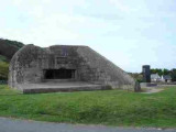
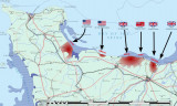
Cap d'Antifer Port pétrolier du Havre - AntiferDans cette zone se trouvent las plages du débarquement du 6 Juin 1944.
6 Jun 19
2nids

The Scilly Isles - Start Point

140nm
267°
The water separating the coast of England from that of France is known in the United Kingdom as the English Channel, and in France as La Manche.The climate of the English Channel is controlled to a large extent by the series of cyclonic disturbances that usually move toward the E ...
5 May 12
Geof

Start Point - Selsey Bill

39nm
322°
From Start Point to the Bill of Portland, 50 miles NE, the coast curves inward in a broad sweep, the N portion of which is Lyme Bay. Between the Bill of Portland and Saint Catherine’s Point, at the S end of the Isle of Wight, the coast is divided into two bays by the Isle of Purbeck.
The ...
3 Jun 12
dd

Selsey Bill - North Foreland

100nm
53°
Shipping lanes in the area are among the busiest in the world and for the safety of navigation Traffic Separation Schemes have been introduced to alleviate maritime casualties.
The United Kingdom Department of Transport view is that if a vessel, other than one less than 20m in ...
5 May 12
Geof

Bretagne Nord

87nm
211°
La navigation  en Bretagne Nord exige l'attention car les courants de marée y sont généralement importants:- vers l'Est à marée montante,
- vers l'Ouest à marée descendanteTermes liés à la maréeAmplitude: Différence entre la hauteur d'une pleine mer ...
21 Jul 12
AB

Pas de Calais - Dover Straight

142nm
73°
Dover Strait , 18 miles wide at its narrowest part, separates the SE coast of England from the N coast of France. This stretch of water contains a number of dangerous banks, which are composed of coarse sand and broken shells. These shoal banks, which are comparatively narrow, extend ...
22 Jan 12
Abu2