Carey island (Selangor - Malaysia)

Carey island (Selangor - Malaysia)

Para ubicar con precisión. Actualizar si es necesario.

Ubicación

Carey island (Selangor - Malaysia)
LatitudeLongitude
DMS------
DM------
DD------

Característica

Isla / Atoll

Descripción

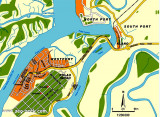
Carey Island or Pulau Carey is an island in Selangor, Malaysia.
Carey Island is located to the south of Port Klang and north of Banting town.
It is a huge island separated from the Selangor coast by the Langat River, connected by a bridge from Chondoi and Teluk Panglima Garang near Banting.
It was named after Valentine Carey, a former British civil service officer in Malaya. Despite its name, many locals from Klang do not consider it a real island compared to Pulau Ketam due to its proximity to the mainland and the river that separates it from the mainland is practically a stream.

It is famous for its seafood such as crabs, prawns, and various fishes. The island has palm oil plantations.

2011/12/28
Actualizar
Jojo
Ebook

Strait of Malacca (East)

  • 83 sites
  • 69 photos
  • publication date: 11 Jul 2023
  • .pdf file size: 35 Mb
Comparta sus comentarios o fotos en "Carey island (Selangor - Malaysia)"

Sitios alrededor de Carey island (Selangor - Malaysia)

Flying distances - Direct line

Pyramid shoal (Malaysia)

30nm
154°
Pyramid Shoal, which lies on the N side of the SE end of South Sands, has a least depth of 3.4m, hard sand, and is the most dangerous shoal in the area because of its depth and protrusion into the fairway.
A lighted buoy is moored about 7 miles SE of Pyramid Shoal. A depth of about ...
28 Dec 11
Jojo

Tanjong Selat Lumut (Perak - Malaysia)

4.3nm
258°
Selat Lumut separates the E side of Pulau Lumut from the mainland. It has a least width of about 0.1 mile, with both sides of the S entrance fringed by mud banks. Selat Lumut has not been surveyed in detail, but appears to be navigable by vessels of not more than 3m draft.
From ...
28 Dec 11
Jojo

Tanjong Ru (Pulau Carey - Malaysia)

4.9nm
231°
Tg Ru is located E side of the approach to Selat Kelang, on Pulau Carey, It is the S point of the South fairway of port Klang .
The coast between Tanjong Ru and Tanjong Gabang, about 15 miles SE, is indented about midway along its length by Kuala Langat. This shallow river is not ...
29 Dec 11
Jojo

Port Klang (Kelang) (Selangor - Malaysia)

6.6nm
13°
Port Klang is the principal port in Selangor.  It also serves as the port for the Klang Valley, Malaysia's most developed region where the capital Kuala Lumpur (that lies 40 miles to the E) is located. The port is situated on the W coast of the Malaysian Peninsula at the N end ...
28 Dec 11
Jojo

Kuala Langat (Selangor - Malaysia)

5.9nm
150°
Kampong Morib, which is conspicuous, stands 3.75 miles SSE of the entrance of Kuala Langat. Kuala Langat is famous for its agricultural produce, industries that recycle scrap metal, home stay programmes for tourists and for its National Space Centre in Kanchong Darat.
Fishermen's ...
29 Dec 11
Jojo

Tanjong Gabang (Selangor - Malaysia)

13nm
150°
Tg Gabang has a light easily identified. It is located before Kampong Batu Laut that stands at the mouth of a small river about 2 NM SE of the point.Between Tanjong Gabang and the entrance of the Sungai Sepang Besar, about 16 miles ESE, the thickly wooded coast is fringed by a sand ...
29 Dec 11
Jojo