Cabo Norte is the limit of the estuary of the Amazon river. It is 19 NM from Ilha Jipioca. The cape is low, wooded, and slightly higher than the neighboring coast.
Cabo Orange (cape Orange) is a cape on the N coast of Brazil, separated from the coast of French Guiana by a large bay watered by the estuary of the Oyapock River Cape Orange is the northernmost point of the Brazilian state of Amapá. It is located in an area of tidal marshland protected ...
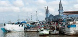
Stands on the W bank of the rio Tocantins, about 90 NM from Belem. The town is built on the river bank and is an important trade center. The tidal range is about 3m; the current attains a rate of about 2.5 knots.
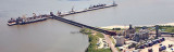
Vila do Conde has a causeway extending 450m from the shore leading to a jetty which serves an aluminum factory. The outer berth is 292m long and is used for handling bulk cargo. The inner berth is 251m long and is used for handling general cargo and aluminum ingots. The depths alongside ...
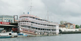
The port of Belem is the most important commercial port on the N coast of Brazil. The port is situated on the E bank of the Rio Para about 70 miles from its mouth. Communication is maintained with all inland Amazon ports.
This is the best port at which to enter Amazonia, but ...
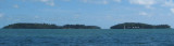
Îles du Salut, 3 in number, are located about 7 NM NE of Pointe Charlote.Ile du Diable, the northernmost, is 40m high. Ile Royale, 66m high, is the largest and westernmost, while Ile Saint-Joseph, only 30m high, is the southernmost.


 Cabo Norte is the limit of the estuary of the Amazon river. It is 19 NM from Ilha Jipioca.
")