The coast between Worli Point, the NW extremity of Bombay Island, and Malabar Point, about 5.3 miles SSW, is fringed by drying reefs and shoal water, with depths of less than 5.5m extending up to 1 mile offshore in the N part and about 0.5 mile off the S part. A conspicuous TV tower lies at an elevation of 305m, 1.5 miles SSE of Worli Point.
Depths in the approach to the coast between Mumbai (Bombay) and Cape Rama are fairly deep and clear of dangers, with the exception of Angria Bank.Angria Bank, with a least depth of 20.1m in position 16°43'N, 72°03'E, lies about 65 miles off the coast, and is composed of sand, shells, ...
Dongri Point, the S entrance point of Bassein Creek, is a bluff point as seen from seaward. It rises to an elevation of 94m about 0.5 mile S of the point, and then slopes gradually to level country about 2 miles farther S. A light is shown from about mid-September to mid-June.Poshpir, ...
Arnala Island, 4m high with a fort on it, lies about 0.5 mile offshore, and is fringed by rocks on all sides. Shoal water, with depths of less than 5m, extends about 1 mile W of the island. Arnala Island has been reported to give good radar returns at 27 miles. Arnala Light is ...
Korlai Fort, on the S side of Kundalika River entrance, stands on the summit of a reddish-colored headland, connected to the mainland by a low, narrow, and sandy isthmus. The N part of this headland slopes gradually to the sea and terminates in a rocky point. A light, with a racon, ...
Kumbaru Point, 70m high, lies about 3.5 miles S of Nanwell Point and is the N entrance point of Kumbaru Bay. The point fronts densely wooded hills rising to about 240m; there is a conspicuous bluff about 2.3miles E of the point. Shah Jehan Shoal, with a least depth of 4.2m, lies ...


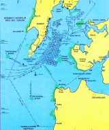


 The coast between Worli Point, the NW extremity of Bombay Island, and Malabar Point, about 5.3 miles SSW, is fringed by drying reefs and shoal water, with depths of less than 5.5m extending up to 1 mile offshore in the N part and about 0.5 mile off the S part.