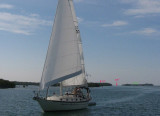
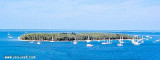
Wisteria Island, also known as Christmas Tree Island, is a privately-owned. It is located 280 yards (260 m) north-northeast of Sunset Key (Tank Island), its closest neighbor.
Large numbers of liveaboard boats are moored near the island, which has recently become the center of a debate over development.
The nickname Christmas Tree Island comes from the large number of Australian pine (casuarina) trees that grow there.
Wisteria Island was created in the late 1890s and early 1900s as the result of U.S. Navy dredging of Key West harbor.
2010/03/19
Update
Joëlle
Wisteria Island, également connu comme l'île Christmas Tree, est une propriété privée qui est située à 280 yards (260 m) au nord-nord-est de Sunset Key (Tank Island), sa plus proche voisine. Un grand nombre de bateaux de croisière sont amarrés à proximité de l'île, qui est récemment devenue le centre d'un débat sur le développement.
Son surnom de Christmas Tree vient du grand nombre de Filao, arbres qui poussent sur cette île.
Wisteria Island a été créé dans la fin des années 1890 et début des années 1900 comme le résultat du dragage du port de Key West.
2010/03/19
Update
Joëlle
Share your comments or photos on "Wisteria Island (Florida Keys)"
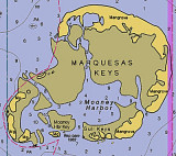
The Marquesas Keys (not to be confused with the Marquesas Islands (French Polynesia in the Pacific Ocean) form an uninhabited island group about 30 miles (50 km) west of Key West, 4 miles (6 km) in diameter, and overgrown by mangrove. They are protected as part of the Key ...
Boca Chica Key is an island in the lower Florida Keys approximately 3 miles east of the island of Key West. Its name is Spanish for "small mouth", (not "girl mouth" as many assume, since chica used as an adjective in Spanish means small).It is mainly composed of salt marshes (mangroves) ...
Stock Island is an island in the lower Florida Keys immediately east of Key West (separated from Key West by Cow Key Channel, which is only about 75 yards (70 m) wide).Immediately northwest is Key Haven (official name Raccoon Key), from which it is connected by causeway with US 1 ...
Fleming Key is an island off the northwest corner of the island of Key West, Florida in the lower Florida Keys. It is roughly 2 miles (3.2 km) long by a quarter mile wide. It is connected to the island of Key West by the Fleming Key Bridge. The island and bridge ...
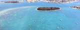
Northwesterly anchorage of Wisteria Island in 6 feet depth. Give attention at wrecks in W offshore from the island.Wide open to northern, northeastern, western and southwestern winds.
We can anchor E of Wisteria Island, to the W of the main ship channel, in minimum depth of 8 feet. Open to southern, northern and northeasterly winds.Anchoring in the vicinity of Key West Bight Channel Light 2, between KeyWest Bight Channel and the shoreline, is not recommended ...


")
 Wisteria
 Wisteria