White Cliffs on Dover

White Cliffs on Dover

To precisely geolocate this site. Update if necessary.

Localisation

White Cliffs on Dover
LatitudeLongitude
DMS------
DM------
DD------

Characteristics

Coast

Description

The White Cliffs of Dover on the English coast are one of the most well known English landmarks. They can be seen from Calais and from the Channel. 

They hold a special value in English history.

2015/02/15
Update
Ebook

Manche - English Channel

  • 240 sites
  • 186 photos
  • publication date: 7 Jul 2023
  • .pdf file size: 229 Mb
Share your comments or photos on "White Cliffs on Dover"

Sites around White Cliffs on Dover

Flying distances - Direct line

South Foreland Lighthouse

0.1nm
44°
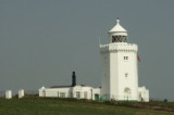
South Foreland Lighthouse is a Victorian lighthouse on the South Foreland used to warn ships approaching the nearby Goodwin Sands. It went out of service in 1988 and is currently owned by the National Trust. South Foreland was the first lighthouse to use an electric light. By 1875 ...
14 Sep 15
dd

Dover Harbor

1.3nm
235°
Port protected by a breakwater.
27 Aug 11
dman4u

Dover

2.1nm
225°
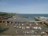
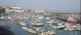
ROYAL CINQUE PORTS YACHT CLUBDon't neglect to visit the Royal Cinque Ports Yacht Club when in Dover.  We are situated on the harbour front with outstanding views of the harbour from the terrace.  The club is only 5 minutes' walk from the marinas, and we welcome visiting ...
1 Feb 12
Atb

Folkestone Harbour

7.6nm
242°
Port protected by a breakwater. Visitor Mooring Fees: Daily mooring fees are £25.00 per 24 hours (in 2015) or part thereof (maximum 10 meter limit)
27 Aug 11
dd

Ramsgate

11nm
Attention au banc de sable à tribord en entrant dans le port de plaisance, serrer à babord
23 Apr 16

Cap Gris Nez

18nm
153°
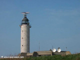
Cap Gris-Nez (50°52'N., 1°35'E.), a precipitous headland, is 50m high and steep-to on its W side. A light is shown from a conspicuous tower, 31m high, standing on the cape.
The CROSS surveillance station and a radar tower are situated close N of the light. Pointe du Riden, located ...
22 Jan 12
Abu2