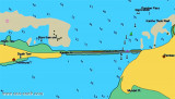
Kariya Shuli and Vilangu Shuli islets (Pattanamarudur-E India)
26nm
241°
The bight is filled by a flat, with depths of less than 5.5m, extending up to about 4.5 miles offshore. Kariya Shuli and Vilangu Shuli, ...
20 Mar 12
Jojo
| Latitude | Longitude | |
| DMS | --- | --- |
| DM | --- | --- |
| DD | --- | --- |

 Caution.—Vessels, other than small coasting vessels, should not approach the coast between Tuticorin and Valinokkam Point, about 37 miles NE, closer than 6 or 7 miles due to the many off-lying shoals.
The coast between Valinokkam Point and Ramen Point, about 32 miles ENE, is fronted by a chain of islands and shoals extending up to 6 miles offshore. Depths outside this chain of islands and shoals are regular, but in places overfalls occur.
An anchorage is located 2.5 miles NE of Valinokkam Point. A dangerous rock lies about 1 mile WSW of the anchorage.
Large vessels should not navigate in depths less than 22m off this stretch of coast as the area is imperfectly surveyed and several relatively shoal patches are charted. They should not sight any of the islands of which the chain is composed.
Kilakkarai Passage, the shallow passage between the chain and the coast, can only be used by small vessels; local knowledge is necessary due to the numerous shoals, with depths of less than 1.8m, and the narrow, undefined channels between them. The passage affords a smooth passage for small coastal vessels for half the distance between Tuticorin and Pamban.
Valinokkam Point is marked by a beacon, 6m high. A submerged rock is marked by a beacon about 1.5 miles NE. These beacons are useful marks for vessels making the W entrance of Kilakarrai Passage, between Valinokkam Point and Anaipar Tivu (Anapipar Tivu), about 2 miles E.
The passage then leads S of a submerged rock, marked by a beacon, about 4 miles ENE of Valinokkam Point, and then to the anchorage off Kilakarrai. A light is shown from a white hexagonal concrete tower with red bands, 30m high, at Kilakkarai.
Ebook | Bay of Bengal
|