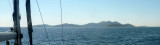
Located at the SE end of the canal Pasmanki and about 2 M SE of Biograd. The bay is lined by a holiday resort and is popular with swimmers and windsurfers. Beware of shoals and rocks on the side S and SE direction Otocic Ostarije. Their end S is indicated by a light. We must stay at least 0.3 million of the island and shoals, entering the bay. Sheltered from the Bora but not at Sirocco. We anchor by 7 or 8 m.
2011/08/14
Update
Croatia
2011:08:13 18:17:25
2011-08-14
Update
Croatia
Située à l'extrémité SE du canal Pasmanki et à environ 2 M au SE de Biograd.
Cette baie est bordée par un complexe de vacances et est très fréquentée par les nageurs et véliplanchistes.
Attention aux hauts-fonds et aux roches sur le côté S et le SE en direction de Otocic Ostarije. Leur extrémité S est indiquée par un feu. Il faut se tenir à au moins 0,3 M de l'île et des hauts-fonds en entrant dans la baie.
Vrgadski Kanal, 7 miles long, leads between Otok Murter and Otok Vrgada and is the principal channel used in the S approach to Pasmanski Kanal and Zadar. Vessels with a maximum draft of 6.4m may pass through Pasmanski Kanal. Vessels with drafts over 6.4m must either proceed through ...
Novigradsko More, a landlocked bay, lies at the S end of Novsko Zdrilo and provides good anchorage. Rijeka Zrmanja flows into the bay at the E side. This river is navigable by small craft as far as the village of Obrovca, 6 miles above the mouth. Luka Novigrad, a narrow inlet, ...
Otok Zirje
is the farthest and the largest island in the Sibenik archipelago. It is long of 6,5 NM (NW/SE) and 1,4 NM wide. The main village, Zirje, is located in the middle of the island. A small port, luka Muna, on the coast N of Zirje, home to the ferry that connects the ...
Kanal Nove Povljane, entered between Otok Vir and the SE end of Otok Pag, leads 5 miles SE into Ninski Zaliv. Shoals at the inner end of this channel restrict the fairway to a width of about 250m, with a controlling depth of 8m. Vessels with a draft of over 6m are advised not to ...
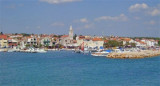
Pakostane is a small tourist town in front of which there are three small islands (Justina, Skolk, Babuljas) only a few tens of meters from shore. It is situated between Lake Vrana and the Adriatic Sea.Approach: the best approach to the N becomes E Babuljas Island, which is a chapel. ...


 Located at the SE end of the canal Pasmanki and about 2 M SE of Biograd.
 Située à l'extrémité SE du canal Pasmanki et à environ 2 M au SE de Biograd.