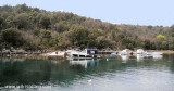
This bay is protected from winds and Bora S. There is a convent on Rt Glavotok and a mole that has a fire. Anchor near the shore to the place that offers the best protection, by 40 m deep.
The bay is exposed to the sea and winds of N and W.
2011/08/2
Update
Jojo
Cette grande baie est protégée de la Bora et des vents du S. Il y a un couvent sur Rt Glavotok et un môle qui porte un feu.
Mouiller près du rivage à l'endroit qui offre la meilleure protection, par 40 m de fond.
La baie est exposée à la mer et aux vents de N et W.
Kanal Vela Vrata connects the N end of Kvarner to Rijecki Zaliv and leads between the N end of Otok Cres, on the E side, and the mainland coast, on the W side. The channel is deep and clear, the bottom being formed of mud.
Otok Plavnik lies with Rt Veli Pin, its N extremity, located 0.7 mile E of the E side of Otok Cres and divides Srednja Vrata in its S part into two channels. This cliffy island is 194m high and partly wooded. Several small islets lie on a shoal bank which extends about 1.5 miles ...
Kanal Krusija leads to the W of Otok Plavnik. This channel is frequented because of its steep-to shores and deep passage. A strong current may occasionally be experienced in this channel, depending on local weather conditions, but this passage is recommended over the one leading ...
The large natural inlet Zaljev Rasa offers the best protection of all sectors of the entire E coast of Istria, while the Bora blows strongly here. This bay is sinking into the earth near 6M, between Rt Ubac and Rt Mulac. The Rijeka Rasa flows into the bottom, creating a current that ...
Tihi Kanal, 3 miles long, connects the NW end of Vinodolski Kanal to Rijecki Zaliv. The channel is deep and tortuous and leads between the mainland and the NE end of Otok Krk.
This cove offers good protection from the SE W by N. Amer: the ruins of a tall building close to the entrance to the N. Anchor by 5 m deep, in front of the villa on the E. bank


 This bay is protected from winds and Bora S. There is a convent on Rt Glavotok and a mole that has a fire.
 Cette grande baie est protégée de la Bora et des vents du S. Il y a un couvent sur Rt Glavotok et un môle qui porte un feu.
")