Kanal Vela Vrata connects the N end of Kvarner to Rijecki Zaliv and leads between the N end of Otok Cres, on the E side, and the mainland coast, on the W side. The channel is deep and clear, the bottom being formed of mud.
Otok Plavnik lies with Rt Veli Pin, its N extremity, located 0.7 mile E of the E side of Otok Cres and divides Srednja Vrata in its S part into two channels. This cliffy island is 194m high and partly wooded. Several small islets lie on a shoal bank which extends about 1.5 miles ...
Kanal Krusija leads to the W of Otok Plavnik. This channel is frequented because of its steep-to shores and deep passage. A strong current may occasionally be experienced in this channel, depending on local weather conditions, but this passage is recommended over the one leading ...
The large natural inlet Zaljev Rasa offers the best protection of all sectors of the entire E coast of Istria, while the Bora blows strongly here. This bay is sinking into the earth near 6M, between Rt Ubac and Rt Mulac. The Rijeka Rasa flows into the bottom, creating a current that ...
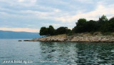
Uvala Sveta Fuska Bay, located about 4.5 M to the W of Krk is one blow away when Bora and Sirocco. Fishing boats and small craft are moored in the bay. The environment is noisy due to road access port for easy access to tourists who bathe in the bay.
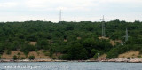
Cove, neighboring Uvala Grkmork, SE of U. Fuska, traveled by a power line that can provide electricity to neighboring island of Cres. This forbidden line in part because of the submarine cable that connects to Krk Cres.


")
")
 This cove offers good protection from the SE W by N.
 Cette anse offre une bonne protection de l'W au SE par le N.