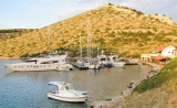
Berth: along first two moles (on the N side of the port). Mooring:
before the moles (depth of 3 m); (bigger vessels) on the outer part of
the bay (depths from 15-20 m). Shallows; along heads of first two moles
(1.5-2 m); in the very end of the E part of the port (0.5 m).
Exposed to W wind; sheltered from bora and jugo.
2011/07/16
Update
Jojo
Les fonds de cette baie sont importants (15/20 m). Un petit quai au fond de la baie permet d'amarrer son bateau par 3 m, s'il y a de la place. Attention à la tête de chaque quai il y a des hauts-fonds (1,5/2m). A l'extrémité E du port les fonds remontent à 0,5 m.
Exposée au vent d'W, protégée de la Bora et du Jugo.
Vrgadski Kanal, 7 miles long, leads between Otok Murter and Otok Vrgada and is the principal channel used in the S approach to Pasmanski Kanal and Zadar. Vessels with a maximum draft of 6.4m may pass through Pasmanski Kanal. Vessels with drafts over 6.4m must either proceed through ...
Kanal Nove Povljane, entered between Otok Vir and the SE end of Otok Pag, leads 5 miles SE into Ninski Zaliv. Shoals at the inner end of this channel restrict the fairway to a width of about 250m, with a controlling depth of 8m. Vessels with a draft of over 6m are advised not to ...
Otok Zirje
is the farthest and the largest island in the Sibenik archipelago. It is long of 6,5 NM (NW/SE) and 1,4 NM wide. The main village, Zirje, is located in the middle of the island. A small port, luka Muna, on the coast N of Zirje, home to the ferry that connects the ...
This island is located at W of O. Kornat, facing, at S, to Rt Kranejak (on O. Kornat), and in front of Uvala Bele Lucice (Kornat).It offers a spacious bay on N. side and another narrower bay on S.
Novigradsko More, a landlocked bay, lies at the S end of Novsko Zdrilo and provides good anchorage. Rijeka Zrmanja flows into the bay at the E side. This river is navigable by small craft as far as the village of Obrovca, 6 miles above the mouth. Luka Novigrad, a narrow inlet, ...
Located at N of O. Levrnaka this great bay extends deep into the earth. It is protected by the island N Suscica extending its tip E. Do not attempt to pass between it and the point because there are only 0.20 m of water. In the passage between the island and Levrnaka Obrucan Veli ...


 The depths of the bay are important.
 Les fonds de cette baie sont importants (15/20 m).
")