Kanal Nove Povljane, entered between Otok Vir and the SE end of Otok Pag, leads 5 miles SE into Ninski Zaliv. Shoals at the inner end of this channel restrict the fairway to a width of about 250m, with a controlling depth of 8m. Vessels with a draft of over 6m are advised not to ...
Otok Zirje
is the farthest and the largest island in the Sibenik archipelago. It is long of 6,5 NM (NW/SE) and 1,4 NM wide. The main village, Zirje, is located in the middle of the island. A small port, luka Muna, on the coast N of Zirje, home to the ferry that connects the ...
Vrgadski Kanal, 7 miles long, leads between Otok Murter and Otok Vrgada and is the principal channel used in the S approach to Pasmanski Kanal and Zadar. Vessels with a maximum draft of 6.4m may pass through Pasmanski Kanal. Vessels with drafts over 6.4m must either proceed through ...
Novigradsko More, a landlocked bay, lies at the S end of Novsko Zdrilo and provides good anchorage. Rijeka Zrmanja flows into the bay at the E side. This river is navigable by small craft as far as the village of Obrovca, 6 miles above the mouth. Luka Novigrad, a narrow inlet, ...
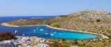
Famous Lojena beach attracts many yachtmen, it is a lovely place to anchor. Exposed to Jugo, sheltered from bora. Mooring: (smaller vessels) in E part of the bay (depth around 3 m);
(bigger vessels) on the middle of the bay (depths 8-15 m). Warning: bay
is not recommended ...
Located at N of O. Levrnaka this great bay extends deep into the earth. It is protected by the island N Suscica extending its tip E. Do not attempt to pass between it and the point because there are only 0.20 m of water. In the passage between the island and Levrnaka Obrucan Veli ...


 This island is located at W of O. Kornat, facing, at S, to Rt Kranejak (on O. Kornat), and in front of Uvala Bele Lucice (Kornat).
 Cette île se trouve à l'W d'O. Kornat, face, au S, à la pointe Kranejak sur O. Kornat, et au N face à Uvala Bele Lucice (Kornat).