Uvala Levrnaka Kornati

Uvala Levrnaka Kornati

To precisely geolocate this site. Update if necessary.

Localisation

Characteristics

Mooring
Sand
Restaurant
Diving
Wreck
Natural Park

Description

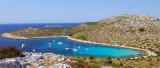
Located at N of O. Levrnaka this great bay extends deep into the earth. It is protected by the island N Suscica extending its tip E. Do not attempt to pass between it and the point because there are only 0.20 m of water.
In the passage between the island and Levrnaka Obrucan Veli (along the direction of the island Levrnaka NW), funds are 2.5 m.
The funds are very important in the middle (22-24 m).
Attention to the wreck submerged in the bottom of the bay which is regularly visited by divers.
This bay is exposed in part to the Bora (swells) and partly Jugo.
Moor along the small pier in the shape of "T" at the bottom of the bay,by 3,5 m or anchored SE of the bayby 10 to 15 m.
2011/07/17
Update
Jojo
Uvala Levrnaka Kornati
2011-07-17
Update
Jojo
Située au N d'O. Levrnaka cette large baie s'enfonce profondément dans la terre. Elle est protégée au N par l'îlot Suscica qui prolonge sa pointe E. Il ne faut pas tenter de passer entre elle et la pointe car il n'y a que 0,20m d'eau.
Dans le passage entre Levrnaka et l'îlot Obrucan Veli (le long du cap NW de l'île Levrnaka), les fonds sont de 2,5 m.

Les fonds sont très importants au centre (22 à 24 m).

Attention à l'épave immergée dans le fond de la baie qui est régulièrement visitée par les plongeurs.

Cette baie est exposée en partie à la Bora (houles) et en partie au Jugo.

On peut s'amarrer le long de la petite jetée en forme de "T", au fond de la baie, par 3,5 m ou ancrer au SE de la baie par 10 à 15 m.
2011/07/17
Update
Jojo
Ebook

Srednji Kanal

  • 44 sites
  • 61 photos
  • publication date: 9 Jul 2023
  • .pdf file size: 15 Mb
Share your comments or photos on "Uvala Levrnaka Kornati"

Sites around Uvala Levrnaka Kornati

Flying distances - Direct line

Otok Murter

15nm
95°
The island of Murter is the largest island of the Sibenik archipelago. It is close to the coast on which it is connected by a bridge, low air draft at Tijesno (Tisno) on the continent. During the summer the bridge opens to allow passage of boats.
The NW part of the island is fertile ...
3 Apr 11
Jojo

Otok Zirje (Sibenik)

20nm
119°
Otok Zirje is the farthest and the largest island in the Sibenik archipelago.
It is long of 6,5 NM (NW/SE) and 1,4 NM wide.
The main village, Zirje, is located in the middle of the island. A small port, luka Muna, on the coast N of Zirje, home to the ferry that connects the ...
16 Aug 11
Croatia

Vrgadski Kanal

12nm
80°
Vrgadski Kanal, 7 miles long, leads between Otok Murter and Otok Vrgada and is the principal channel used in the S approach to Pasmanski Kanal and Zadar.
Vessels with a maximum draft of 6.4m may pass through Pasmanski Kanal. Vessels with drafts over 6.4m must either proceed through ...
16 Jul 11
Jojo

Kanal Nove Povljane Vir

30nm
347°
Kanal Nove Povljane, entered between Otok Vir and the SE end of Otok Pag, leads 5 miles SE into Ninski Zaliv.
Shoals at the inner end of this channel restrict the fairway to a width of about 250m, with a controlling depth of 8m. Vessels with a draft of over 6m are advised not to ...
23 Jul 11
Jojo

Rivanjski Kanal

23nm
332°
Rivanjski Kanal continues NW from the N end of Srednji Kanal and leads between Otok Rivanj andOtok Sestrunj.
It is generally used by vessels proceeding between Srednji and Zadarski Kanals.
Otocic Tri Sestrice, a group of islets and rocks, extend up to 2 miles NW of Rt Zanavin, ...
9 Sep 11
Jojo

Otok Levrnaka Kornati

0.2nm
280°
This island is located at W of O. Kornat, facing, at S, to Rt Kranejak (on O. Kornat), and in front of Uvala Bele Lucice (Kornat).It offers a spacious bay on N. side and another narrower bay on S.
17 Jul 11
Jojo