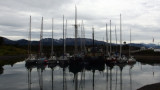
Stanley, on East Falkland, is the capital city. The Falklands has many good anchorages, but on the approach to Stanley one should be aware that on the North coast there are not many places to run into for shelter.
2007/09/25
Update
Share your comments or photos on "Stanley Harbour"
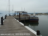
Puerto WilliamsAmarrage à couple du Micalvi, ancien navire ravitailleur posé sur le fond.Taxe d'amarrage à régler à l'armada du Chili.Dans le vieux rafiot, douches et bar. Possibilité de jonction électrique. Tuyau pour plein d'eau.Ravitaillement en fuel à la station-service ...
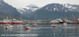
This port is the southernmost port of Argentina and the South American continent.A causeway connects Punta Observatorio with Ushuaia on the NW shore of the bay. The commercial pier is situated on the NW of the bay and is built of cement. The total length is 640m long, with the shore ...
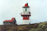
Cape Horn island (Dutch: Kaap Hoorn; Spanish: Cabo de Hornos; named after the city of Hoorn in the Netherlands) is the southernmost headland of the Tierra del Fuego archipelago of southern Chile. It is widely considered to be the southern tip of South America. Cape Horn is the ...


 2007-02-17°
 Stanley, on East Falkland, is the capital city.