
Copenhagen
0nm
180°
26 Jul 26
Anonymous
| Latitude | Longitude | |
| DMS | --- | --- |
| DM | --- | --- |
| DD | --- | --- |
 Kaohsiung
  9,12,14,16,70


")
Ebook | SW Atlantic Ocean
|
")
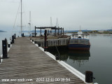
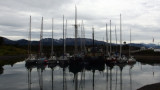
 This port is the southernmost port of Argentina and the South American continent.A causeway connects Punta Observatorio with Ushuaia on the NW shore of the bay. The commercial pier is situated on the NW of the bay and is built of cement. The total length is 640m long, with the shore end extending 160m S, then bending to the SE for another 480m. Depths alongside range from 3.8m near the shore to 10m at the seaward end of the pier.
Two small wooden piers are located close E of the shoreside portion of the commercial pier; these are used for small craft and ferries. A concrete pier, 40m long and 30m wide, used by naval vessels and their support craft, is located further E along the coast from the wooden piers. It hosts the oil storage plant, called Planta Orión.
 El primer muelle de Ushuaia fue construído por la Gobernación bajo la órbita de la Administración General de Puertos. Con la provincialización de Tierra del Fuego en 1991 se comenzó a planificar una ampliación para convertir a Ushuaia en un puerto de aguas profundas. Este proyecto se cristalizó en el Muelle Comercial Puerto Ushuaia que fue culminado en Marzo de 1999.