Puerto Williams

Puerto Williams

To precisely geolocate this site. Update if necessary.

Localisation

Puerto Williams
LatitudeLongitude
DMS------
DM------
DD------

Characteristics

Port

Description

Puerto Williams

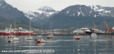
Amarrage à couple du Micalvi, ancien navire ravitailleur posé sur le fond.

Taxe d'amarrage à régler à l'armada du Chili.

Dans le vieux rafiot, douches et bar. Possibilité de jonction électrique. Tuyau pour plein d'eau.

Ravitaillement en fuel à la station-service routière, à 300 m.

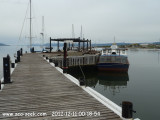
Possibilité de remplissage des bonbonnes de gaz.

Denis, un Suisse qui vit à PW peut gardienner un voilier.

Avitaillement alimentaire basique dans le magasin destiné aux marins de l'Armada du Chili; prix normaux.

2015/04/6
Update
ZOBRA
Puerto Williams
2015:02:03 19:27:43
2015-04-06
Update
ZOBRA
Ebook

Chile

  • 118 sites
  • 166 photos
  • publication date: 6 Jul 2023
  • .pdf file size: 34 Mb
Share your comments or photos on "Puerto Williams"

Sites around Puerto Williams

Flying distances - Direct line

Ushuaia Puerto Comercial (Argentina)

24nm
287°
This port is the southernmost port of Argentina and the South American continent.A causeway connects Punta Observatorio with Ushuaia on the NW shore of the bay. The commercial pier is situated on the NW of the bay and is built of cement. The total length is 640m long, with the shore ...
30 Dec 12
dd

Ushuaia - Club Nautico

24nm
286°
Bahía Ushuaia is well sheltered from the  west but is open to the east. 
27 Dec 12
dd

Cabo de Hornos (Isla Hornos, Cape Horn)

63nm
169°
Cape Horn island (Dutch: Kaap Hoorn; Spanish: Cabo de Hornos; named after the city of Hoorn in the Netherlands) is the southernmost headland of the Tierra del Fuego archipelago of southern Chile.
It is widely considered to be the southern tip of South America. Cape Horn is the ...
22 Oct 07