Srednji Kanal, also known as Middle Channel, has sufficient depths for large vessels. However, it is little used except by vessels proceeding between Sibenik and Zadar which are unable to navigate Pasmanski Kanal. The channel is entered between Otocic Kosara (43°53'N., 15°24'E.) and Hrid Galijolica, 1.5 miles SW, and is generally clear and deep in the middle.
2011/07/16
Update
Jojo
Odcinek I
Sukosan - Zat. Telascica
2013/07/26
Update
Srednji Kanal, également connu sous le nom de Middle Channel, a des profondeurs suffisantes pour les grands navires. Cependant, il est peu utilisé, sauf par des navires navigants entre Sibenik et Zadar qui sont incapables de naviguer dans Pasmanski Kanal. Le canal est inséré entre Otocic Kosara (43 ° 53'N., 15 ° 24'E.) Et HRID Galijolica, 1,5 miles SW, et est généralement clair et profond au milieu.
The
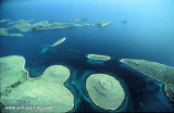
Kornati archipelago is a group of islands located in the center of the
Dalmatian coast, south of Zadar, between Zadar and Sibenik. This
is the densest archipelago in the Mediterranean, it has 150 islands and
islets (most uninhabited) on an area of 320 km ². Croatian ...
O. Iz is between E O. Uglan and W Dugi O., SW of Srednji Kanal and 14 NM of Zadar. It is part of the Zadar archipelago. It is 6,6 NM long, NW to SE and its greatest width does not exceed 1.4 M. Its highest point is Korinjak, top 168 m. The two main villages of the island ...
Otok Zirje
is the farthest and the largest island in the Sibenik archipelago. It is long of 6,5 NM (NW/SE) and 1,4 NM wide. The main village, Zirje, is located in the middle of the island. A small port, luka Muna, on the coast N of Zirje, home to the ferry that connects the ...
Kanal Nove Povljane, entered between Otok Vir and the SE end of Otok Pag, leads 5 miles SE into Ninski Zaliv. Shoals at the inner end of this channel restrict the fairway to a width of about 250m, with a controlling depth of 8m. Vessels with a draft of over 6m are advised not to ...
Vrgadski Kanal, 7 miles long, leads between Otok Murter and Otok Vrgada and is the principal channel used in the S approach to Pasmanski Kanal and Zadar. Vessels with a maximum draft of 6.4m may pass through Pasmanski Kanal. Vessels with drafts over 6.4m must either proceed through ...
Piškera (known as Jadra) is a small uninhabited island and one of the Kornati island. Its area is 2,66 km². Its coastline is 10,64 km long. It is just off the SW coast of O. Kornat, about 3 NM of Vrulje.There are two islands and some reefs on the S coast. O. Panitula Vela, the ...


 Srednji Kanal, also known as Middle Channel, has sufficient depths for large vessels. However, it is little used except by vessels proceeding between Sibenik and Zadar which are unable to navigate Pasmanski Kanal.
 Srednji Kanal, également connu sous le nom de Middle Channel, a des profondeurs suffisantes pour les grands navires. Cependant, il est peu utilisé, sauf par des navires navigants entre Sibenik et Zadar qui sont incapables de naviguer dans Pasmanski Kanal.


