Otok Zirje (Sibenik)
16nm
115°
It is long of 6,5 NM (NW/SE) and 1,4 NM wide.
The main village, Zirje, is located in the middle of the island. A small port, luka Muna, on the coast N of Zirje, home to the ferry that connects the ...
16 Aug 11
Croatia
| Latitude | Longitude | |
| DMS | --- | --- |
| DM | --- | --- |
| DD | --- | --- |

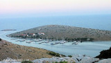
 Piškera (known as Jadra) is a small uninhabited island and one of the Kornati island. Its area is 2,66 km². Its coastline is 10,64 km long. It is just off the SW coast of O. Kornat, about 3 NM of Vrulje.
There are two islands and some reefs on the S coast.
O. Panitula Vela, the larger of two islands, home a marina with 150 berths operated by ACI Club is located on the island, (in the passage between the islands Piškera and Panitula Vela) on the N side of the islet Panitula Vela) open between March and October every year.
Shallow: in the passage between the island Piškera and the islet Veseljuh (along NE side of the island; depth only 2 m).
Warning: from the other side of the island (opposite the marina) there is a cliff Kamičić along which is from its E side one reef.
 Piskera (connu sous le nom Jadra) est une petite île inhabitée et une des îles Kornati. Sa superficie est de 2,66 km². Son littoral est de 10,64 km de long. Elle est juste à côté de la côte SW de O. Kornat, à environ 3 NM de Vrulje.
Il y a deux îles et quelques roches sur la côte S.
O. Panitula Vela, la plus grande des deux îles, abrite une marina avec 150 places exploitée par l'ACI Club est située sur l'île, (dans le passage entre les îles et Piskera Panitula Vela, sur le côté N de l'îlot de Vela Panitula). Elle est ouverte entre Mars et Octobre chaque année.
Profondeur: dans le passage entre l'île et la Piskera Veseljuh îlots (le long du côté nord de l'île, profondeur seulement 2 m).
Attention: à partir de l'autre côté de l'île (en face de la marina) il y a une falaise Kamičić le long de laquelle se trouve un rocher sur son côté E.Ebook | Srednji Kanal
|
Ebook | Dalmacija (Dalmatie)
|