
Otok Kornat (Kornati)
0.8nm
98°
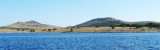
Kornat, with several prominent peaks, lies SE of Dugi Otok and is separated from it by Prolaz Proversa, a narrow channel, which is obstructed ...
16 Jul 11
Jojo
| Latitude | Longitude | |
| DMS | --- | --- |
| DM | --- | --- |
| DD | --- | --- |


Ebook | Srednji Kanal
|
 The
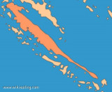
Kornati archipelago is a group of islands located in the center of the
Dalmatian coast, south of Zadar, between Zadar and Sibenik. This
is the densest archipelago in the Mediterranean, it has 150 islands and
islets (most uninhabited) on an area of 320 km ². Croatian proverb says of course there are as many as days in the year.
The
Kornati archipelago is a group of islands located in the center of the
Dalmatian coast, south of Zadar, between Zadar and Sibenik. This
is the densest archipelago in the Mediterranean, it has 150 islands and
islets (most uninhabited) on an area of 320 km ². Croatian proverb says of course there are as many as days in the year. L'archipel des Kornati est un groupe d'îles situées au centre de la côte dalmate, au sud de Zadar, entre Zadar et Sibenik. C'est l'archipel le plus dense de la Méditerranée, il compte 150 îles et îlots (inhabitées pour la plupart) sur une aire de 320 km². Un proverbe croate prétend évidemment qu'il y en a autant que de jours dans l'année.
La fonte des glaciers et la montée des eaux après la dernière ère glaciaire, il y a 20 000 ans, en ont fait un archipel, modelé par le pouvoir érosif de la mer et du vent qui a mis à nu de fines stries de calcaire.
Il y a un siècle, les habitants des îles voisines ont édifié ces pierres en murets pour parquer leurs moutons et isoler leurs cultures d'olivier et de vigne. La surexploitation des maigres herbages a considérablement appauvri la faune et la flore terrestres.
Kornati ça veut dire couronne, les iles kornati "les iles couronnées" car au bord de chaque ile, il y a une bordure de cailloux et vue du ciel ça forme une couronne.Les plaisanciers qui souhaitent visiter les îles Kornati doivent acheter leur billet d'entrée, dans l'un des deux centres d'accueil:
Là, vous pouvez acheter les billets d’entrée pour bateaux, et des permis de pêche récréative ou de plongée sous-marine.
L’ancrage et le camping sur votre bateau n’est autorisé que dans 16 criques précisément indiquées. Les îles où il est interdit de mouiller sont celles de Klobucar, Mrtvac, Veli et Mali Obrucan.
Tout au S des îles, les plaisanciers doivent rester à au moins 500 m de Velika Purara et des récifs débordants de Klint et de Volic.