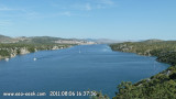
Zirjanski Kanal
9.4nm
256°
This channel, which is deep and clear, is frequently used by vessels proceeding into Murtersko More and can be easily navigated.
1 Jul 11
Jojo
| Latitude | Longitude | |
| DMS | --- | --- |
| DM | --- | --- |
| DD | --- | --- |

 Sibenik-Knin county is located in north-central Dalmatia. The Šibenik Riviera is a hundred kilometres long coastal belt from Rogoznica to Drage in the Zadar County. Its center is Šibenik.Known locally as Sibensko-Kninska Zupanija, Sibenik county contains one of Croatia’s most beautiful National Parks, the Krka Waterfalls.
It is also home to the Vransko Jezero Park, a huge lake which is a sanctuary for birds and is excellent for coarse fishing.
Sibenik-Knin county is located in north-central Dalmatia. The Šibenik Riviera is a hundred kilometres long coastal belt from Rogoznica to Drage in the Zadar County. Its center is Šibenik.Known locally as Sibensko-Kninska Zupanija, Sibenik county contains one of Croatia’s most beautiful National Parks, the Krka Waterfalls.
It is also home to the Vransko Jezero Park, a huge lake which is a sanctuary for birds and is excellent for coarse fishing.The coastline to the south of this region is unusually undulating with numerous small peninsulas jutting out into the sea, on one of which, an almost-island, is the lovely fortress town of Primosten.
Some islands worth a visit like Krapanj, Zlarin, Privc.
 La région de Sibenik-Knin est située au centre N de la Dalmatie. La Riviera de Sibenik a 100 km de côte qui va de Rogoznica à Drage dans la région de Zadar. Son centre est Sibenik.
Localement connue comme "Sibensko-Kninska Zupanija", la région de Sibenik possède un des plus beau parc National de Croatie, les chutes de Krka. Elle abrite aussi le Parc "Vransko Jezero", un énorme lac qui est un sanctuaire pour les oiseaux et excellent pour la pêche au lancer.
Le littoral au sud de cette région est exceptionnellement vallonné avec de nombreuses petites péninsules s'avançant dans la mer, sur l'une desquelles, se trouve la belle ville fortifiée de Primosten.
Certaines îles valent le détour, comme Krapanj, Zlarin, Privc.
Ebook | Šibensko-kninska županija (Šibenik-Knin County)
|
")