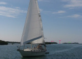
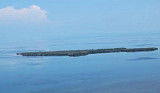
Sand Key light is located 6 nautical miles southwest of Key West, Florida, between Sand Key Channel and Rock Key Channel, two of the channels into Key West. It is located on a reef that is intermittently covered by sand. At times the key has been substantial enough to have trees, and in 1900 nine to twelve thousand terns nested on the island.
At other times the island has been washed away completely. As of 1998, Sand Key was a sand bar with no vegetation.
It is located in lower Biscayne Bay, between Elliott Key and Boca Chita Key.
2010/03/14
Update
JB
2010-03-14
Update
Joëlle
Sand Key light est situé à 6 M au S de Key West, il est adjacent au Southwest channel, un des principaux canaux dans West Key.
Il se trouve sur un récif qui est couvert par le sable de temps en temps.
Certaine fois l'îlot a été suffisamment important pour avoir des arbres, et en 1900 9 à 12000 oiseaux naissaient sur cet îlot. A d'autres époque l'îlot a été complètement recouvert par la mer.
Il est située dans le parc national de Biscayne.
2010/03/14
Update
JB
Share your comments or photos on "Sand Key light (Key west)"
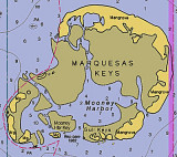
The Marquesas Keys (not to be confused with the Marquesas Islands (French Polynesia in the Pacific Ocean) form an uninhabited island group about 30 miles (50 km) west of Key West, 4 miles (6 km) in diameter, and overgrown by mangrove. They are protected as part of the Key ...
Boca Chica Key is an island in the lower Florida Keys approximately 3 miles east of the island of Key West. Its name is Spanish for "small mouth", (not "girl mouth" as many assume, since chica used as an adjective in Spanish means small).It is mainly composed of salt marshes (mangroves) ...
A convenient approach to Key West from SW, has been swept to a depth of 23 feet, and is marked by buoys. Strangers should not attempt passage at night.
West Channel, a passage leading W from Key West between the keys and outer reefs, is deep but unmarked. It is used by shrimp boats and small craft bound toward the Dry Tortugas. Local knowledge is advised for safe passage.


")
 Sand Key light is located 6 nautical miles southwest of Key West, Florida, between Sand Key Channel and Rock Key Channel, two of the channels into Key West.
")
 Sand Key light est situé à 6 M au S de Key West, il est adjacent au Southwest channel, un des principaux canaux dans West Key.