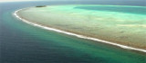
The S side of the atoll is formed by reefs lying between Berriam Faro and Mamanago Faro, about 7 miles SW; three islets lie on this section of the barrier reef.
The SW face of the atoll is formed by Mamanago Faro, at its SW extremity, and three similar lagoon reefs farther N.
Maregiri lies at the S end of the NW side of the atoll. From this islet the barrier reef, consisting of a series of lagoon reefs, some with small unnamed islets, extends about 25 miles NNE. These reefs lack above-water features and are therefore difficult to identify; the channels between them are therefore better avoided, especially since the central part of the lagoon is unsafe for navigation.
Moresby Channel, separating North Malosmadulu Atoll and South Malosmadulu Atoll, has depths over 183m and is free from known dangers. The W entrance to this channel has no wooded islet near it and is difficult to identify.
The Malosmadulu atoll includes goidhoo atoll.
2011/11/8
Update
Jojo
S Malosmadulu (Baa) Atoll
2011-11-08
Update
Jojo
Maddy is awesome
2015/10/6
Update
Le côté S de l'atoll est formé par les récifs situés entre Berriam Faro et Mamanago Faro, à environ 7 miles SW, trois îlots se trouvent sur ce tronçon de la barrière de corail.
Horsburgh Atoll (Goidu Atoll) about 6 miles S of South Malosmadulu Atoll, is considered as part of the latter atoll for administrative purposes. Horsburgh Atoll was reported (1987) to lie approximately 2 miles SE of its charted position. Goidhoo Atoll (also Goidu or Goifulhafehendhu), ...
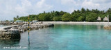
Hanikando Faro, at the NW extremity of the atoll, is separated from Kari Faro, about 0,8 NM S, by an opening into the lagoon. Dukandu, an island, lies in the middle of the inner end of the opening.Kari Faro is a reef enclosing a lagoon, with the islets of Iwafuri and ...
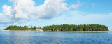
SE Malosmadulu Atoll Maalhoss island characterized by a small lagoon on the west side as a perfect refuge for shallow-draft boats during the northeast monsoon. The entrance is marked by a small lighthouse.
Maalhoss is a tiny island with approximately 500 inhabitants.
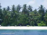
South maaslhosmadulu atoll hithaadhoo is located on the south west in the atoll. Hithaadhoo is 2600 feet long and have 1430 feet in width. A total of about 1171 people are registered in the island. Main occupation of the residance of hithaadhoo is fishing.There is a ...


 Atoll")
 Le côté S de l'atoll est formé par les récifs situés entre Berriam Faro et Mamanago Faro, à environ 7 miles SW, trois îlots se trouvent sur ce tronçon de la barrière de corail.