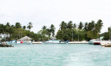


Fehendu and Furudu islands (Goidhoo)
2.3nm
30°
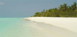
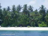
The villages on the N sides of these islands are visible from seaward.
8 Nov 11
Jojo
| Latitude | Longitude | |
| DMS | --- | --- |
| DM | --- | --- |
| DD | --- | --- |


 Horsburgh Atoll (Goidu Atoll) about 6 miles S of South Malosmadulu Atoll, is considered as part of the latter atoll for administrative purposes. Horsburgh Atoll was reported (1987) to lie approximately 2 miles SE of its charted position.
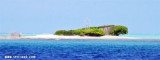
Goidhoo Atoll (also Goidu or Goifulhafehendhu), Horsburgh Atoll in the Admiralty Chart, is separated from South Maalhosmadulhu by a 6 mile broad channel. This atoll is oval in shape and small,it is 8,5 km long and 17,5 km wide. It has three inhabited islands: Goidhoo, Fulhadhoo and Fehendhoo, known collectively as Goi'fulha'fehendhoo. There are three small uninhabited islands.
The inner lagoon has a depth of 17 to 20 fathoms; it has a sandy bottom mixed with mud and clay. Unlike the lagoons of most small atolls of the Maldives, this lagoon is free from coral heads in its centre.
The atoll Goidhoo has only one pass, Doru Kandu, on the south side, about 2 km wide.
Near the edges of large open spaces there are sandy with coral formations. Because of its exposure to the ocean outside the reef and the barrier 'flat and solid.
In the Admiralty charts, this atoll is named after James Horsburgh, hydrographer to the East India Company and author of the long-titled Directions for Sailing to and from the East Indies, China, New Holland, Cape of Good Hope, and the interjacent Ports, compiled chiefly from original Journals and Observations made during 21 years' experience in navigating those Seas. Horsburgh's Directory was the standard work for oriental navigation in the first half of the 19th century, until Robert Moresby's survey of the Maldives when for the first time in history accurate maps of the atolls were published.
The atoll offers a secure anchorage
near the islands in the north-east monsoon.
Anchorage, in 27 to 42m, good holding ground of sand, mud, and clay, can be obtained in the lagoon.
Ebook | Maldives
|